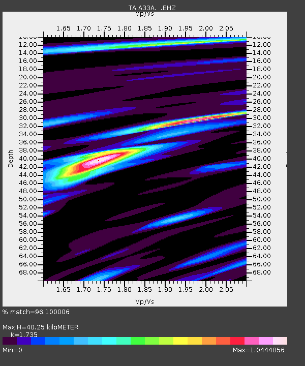
A33A Warroad, MN, USA - Earthquake Result Viewer
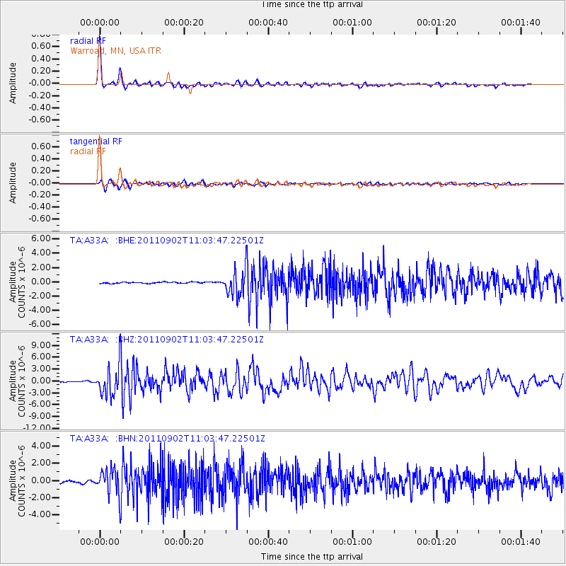
Earthquake location: Fox Islands, Aleutian Islands
Earthquake latitude/longitude: 52.2/-171.7
Earthquake time(UTC): 2011/09/02 (245) 10:55:53 GMT
Earthquake Depth: 32 km
Earthquake Magnitude: 6.5 MB, 6.9 MS, 6.8 MW, 6.8 MW
Earthquake Catalog/Contributor: WHDF/NEIC
Network: TA USArray Transportable Network (new EarthScope stations)
Station: A33A Warroad, MN, USA
Lat/Lon: 48.94 N/95.39 W
Elevation: 329 m
Distance: 46.5 deg
Az: 62.037 deg
Baz: 304.416 deg
Ray Param: 0.07054608
Estimated Moho Depth: 40.25 km
Estimated Crust Vp/Vs: 1.74
Assumed Crust Vp: 6.419 km/s
Estimated Crust Vs: 3.7 km/s
Estimated Crust Poisson's Ratio: 0.25
Radial Match: 96.100006 %
Radial Bump: 320
Transverse Match: 90.84531 %
Transverse Bump: 400
SOD ConfigId: 414626
Insert Time: 2012-01-18 07:27:55.269 +0000
GWidth: 2.5
Max Bumps: 400
Tol: 0.001

Signal To Noise

ChannelStoNSTALTA
TA:A33A: :BHZ:20110902T11:03:47.22501Z27.949423.7957816E-61.3580895E-7
TA:A33A: :BHN:20110902T11:03:47.22501Z17.490461.5098891E-68.632644E-8
TA:A33A: :BHE:20110902T11:03:47.22501Z21.0698741.8526082E-68.792687E-8
Arrivals
Ps4.9 SECOND
PpPs16 SECOND
PsPs/PpSs21 SECOND