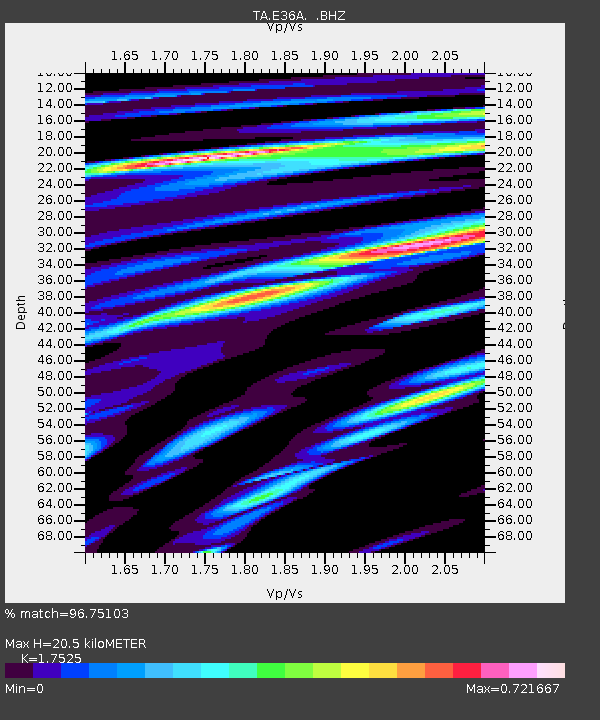
E36A McGregor, MN, USA - Earthquake Result Viewer
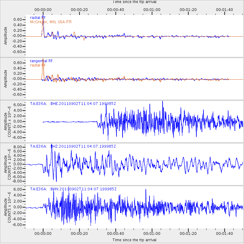
Earthquake location: Fox Islands, Aleutian Islands
Earthquake latitude/longitude: 52.2/-171.7
Earthquake time(UTC): 2011/09/02 (245) 10:55:53 GMT
Earthquake Depth: 32 km
Earthquake Magnitude: 6.5 MB, 6.9 MS, 6.8 MW, 6.8 MW
Earthquake Catalog/Contributor: WHDF/NEIC
Network: TA USArray Transportable Network (new EarthScope stations)
Station: E36A McGregor, MN, USA
Lat/Lon: 46.52 N/93.26 W
Elevation: 393 m
Distance: 49.1 deg
Az: 63.554 deg
Baz: 307.011 deg
Ray Param: 0.06886802
Estimated Moho Depth: 20.5 km
Estimated Crust Vp/Vs: 1.75
Assumed Crust Vp: 6.571 km/s
Estimated Crust Vs: 3.749 km/s
Estimated Crust Poisson's Ratio: 0.26
Radial Match: 96.75103 %
Radial Bump: 400
Transverse Match: 89.4541 %
Transverse Bump: 400
SOD ConfigId: 414626
Insert Time: 2012-01-18 07:28:55.553 +0000
GWidth: 2.5
Max Bumps: 400
Tol: 0.001

Signal To Noise

ChannelStoNSTALTA
TA:E36A: :BHZ:20110902T11:04:07.199985Z35.8216173.3972565E-69.4838164E-8
TA:E36A: :BHN:20110902T11:04:07.199985Z17.333981.2739073E-67.3491904E-8
TA:E36A: :BHE:20110902T11:04:07.199985Z31.545671.9828622E-66.285687E-8
Arrivals
Ps2.5 SECOND
PpPs8.1 SECOND
PsPs/PpSs11 SECOND