You are here: Home > Network List > TA - USArray Transportable Network (new EarthScope stations) Stations List
> Station O56A Blue Knob State Park, Imler, PA, USA > Earthquake Result Viewer
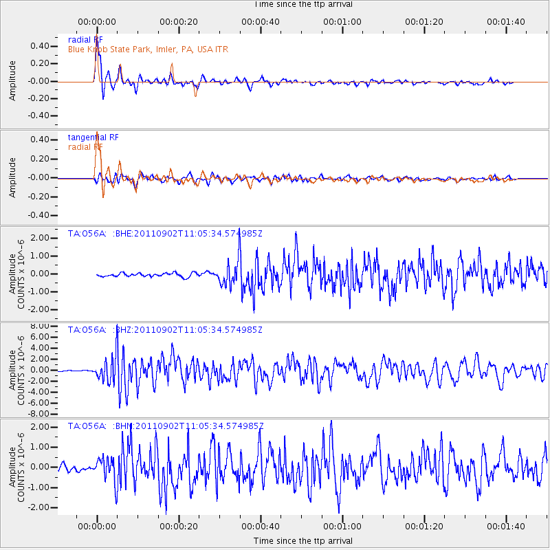
O56A Blue Knob State Park, Imler, PA, USA - Earthquake Result Viewer

| Earthquake location: |
Fox Islands, Aleutian Islands |
| Earthquake latitude/longitude: |
52.2/-171.7 |
| Earthquake time(UTC): |
2011/09/02 (245) 10:55:53 GMT |
| Earthquake Depth: |
32 km |
| Earthquake Magnitude: |
6.5 MB, 6.9 MS, 6.8 MW, 6.8 MW |
| Earthquake Catalog/Contributor: |
WHDF/NEIC |
|
| Network: |
TA USArray Transportable Network (new EarthScope stations) |
| Station: |
O56A Blue Knob State Park, Imler, PA, USA |
| Lat/Lon: |
40.27 N/78.57 W |
| Elevation: |
684 m |
|
| Distance: |
61.2 deg |
| Az: |
60.653 deg |
| Baz: |
315.444 deg |
| Ray Param: |
0.060960367 |
| Estimated Moho Depth: |
41.0 km |
| Estimated Crust Vp/Vs: |
1.82 |
| Assumed Crust Vp: |
6.121 km/s |
| Estimated Crust Vs: |
3.363 km/s |
| Estimated Crust Poisson's Ratio: |
0.28 |
|
| Radial Match: |
94.24817 % |
| Radial Bump: |
400 |
| Transverse Match: |
80.29446 % |
| Transverse Bump: |
400 |
| SOD ConfigId: |
414626 |
| Insert Time: |
2012-01-18 07:30:15.768 +0000 |
| GWidth: |
2.5 |
| Max Bumps: |
400 |
| Tol: |
0.001 |
|
Signal To Noise
| Channel | StoN | STA | LTA |
| TA:O56A: :BHZ:20110902T11:05:34.574985Z | 15.180819 | 2.2395745E-6 | 1.475266E-7 |
| TA:O56A: :BHN:20110902T11:05:34.574985Z | 6.7758956 | 5.9924116E-7 | 8.843719E-8 |
| TA:O56A: :BHE:20110902T11:05:34.574985Z | 7.1163406 | 7.0982037E-7 | 9.974513E-8 |
| Arrivals |
| Ps | 5.7 SECOND |
| PpPs | 18 SECOND |
| PsPs/PpSs | 24 SECOND |


