You are here: Home > Network List > TA - USArray Transportable Network (new EarthScope stations) Stations List
> Station M36A Felix, Anita, IA, USA > Earthquake Result Viewer
M36A Felix, Anita, IA, USA - Earthquake Result Viewer
| Earthquake location: |
Fox Islands, Aleutian Islands |
| Earthquake latitude/longitude: |
52.2/-171.7 |
| Earthquake time(UTC): |
2011/09/02 (245) 10:55:53 GMT |
| Earthquake Depth: |
32 km |
| Earthquake Magnitude: |
6.5 MB, 6.9 MS, 6.8 MW, 6.8 MW |
| Earthquake Catalog/Contributor: |
WHDF/NEIC |
|
| Network: |
TA USArray Transportable Network (new EarthScope stations) |
| Station: |
M36A Felix, Anita, IA, USA |
| Lat/Lon: |
41.45 N/94.80 W |
| Elevation: |
430 m |
|
| Distance: |
51.4 deg |
| Az: |
69.619 deg |
| Baz: |
309.823 deg |
| Ray Param: |
0.06740857 |
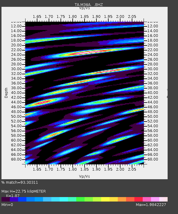
| Estimated Moho Depth: |
22.75 km |
| Estimated Crust Vp/Vs: |
1.87 |
| Assumed Crust Vp: |
6.498 km/s |
| Estimated Crust Vs: |
3.475 km/s |
| Estimated Crust Poisson's Ratio: |
0.30 |
|
| Radial Match: |
93.30311 % |
| Radial Bump: |
400 |
| Transverse Match: |
89.28273 % |
| Transverse Bump: |
400 |
| SOD ConfigId: |
414626 |
| Insert Time: |
2012-01-18 07:30:32.046 +0000 |
| GWidth: |
2.5 |
| Max Bumps: |
400 |
| Tol: |
0.001 |
|
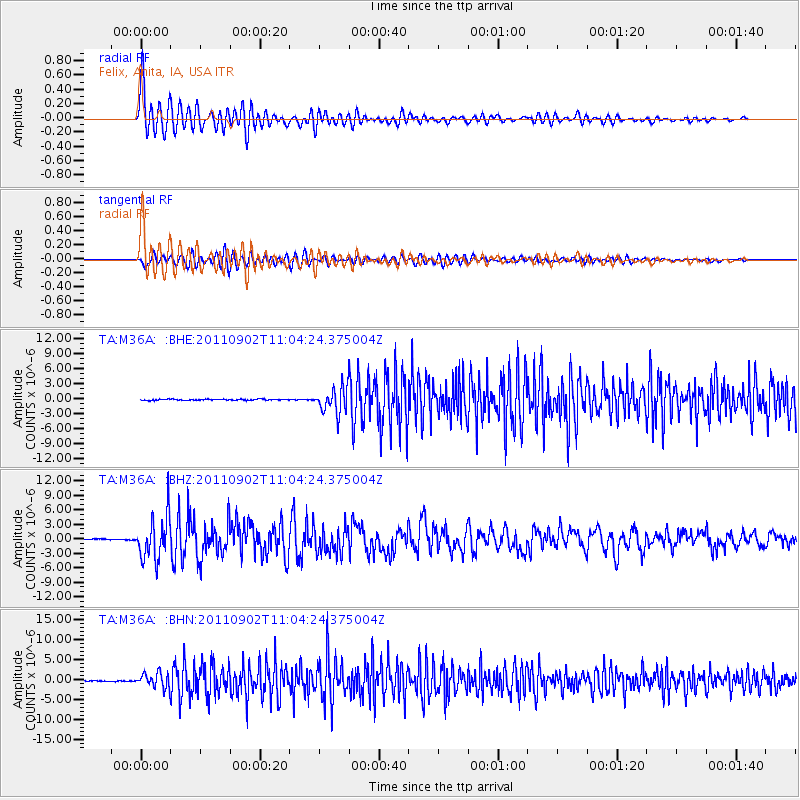
Signal To Noise
| Channel | StoN | STA | LTA |
| TA:M36A: :BHZ:20110902T11:04:24.375004Z | 45.273033 | 4.4493204E-6 | 9.8277496E-8 |
| TA:M36A: :BHN:20110902T11:04:24.375004Z | 20.527184 | 1.8421202E-6 | 8.9740524E-8 |
| TA:M36A: :BHE:20110902T11:04:24.375004Z | 21.363356 | 2.5155339E-6 | 1.1774995E-7 |
| Arrivals |
| Ps | 3.2 SECOND |
| PpPs | 9.5 SECOND |
| PsPs/PpSs | 13 SECOND |


