You are here: Home > Network List > TA - USArray Transportable Network (new EarthScope stations) Stations List
> Station N59A State Game Land 141, Hazleton, PA, USA > Earthquake Result Viewer
N59A State Game Land 141, Hazleton, PA, USA - Earthquake Result Viewer
| Earthquake location: |
Fox Islands, Aleutian Islands |
| Earthquake latitude/longitude: |
52.2/-171.7 |
| Earthquake time(UTC): |
2011/09/02 (245) 10:55:53 GMT |
| Earthquake Depth: |
32 km |
| Earthquake Magnitude: |
6.5 MB, 6.9 MS, 6.8 MW, 6.8 MW |
| Earthquake Catalog/Contributor: |
WHDF/NEIC |
|
| Network: |
TA USArray Transportable Network (new EarthScope stations) |
| Station: |
N59A State Game Land 141, Hazleton, PA, USA |
| Lat/Lon: |
40.92 N/75.77 W |
| Elevation: |
508 m |
|
| Distance: |
62.2 deg |
| Az: |
58.407 deg |
| Baz: |
316.193 deg |
| Ray Param: |
0.06030321 |
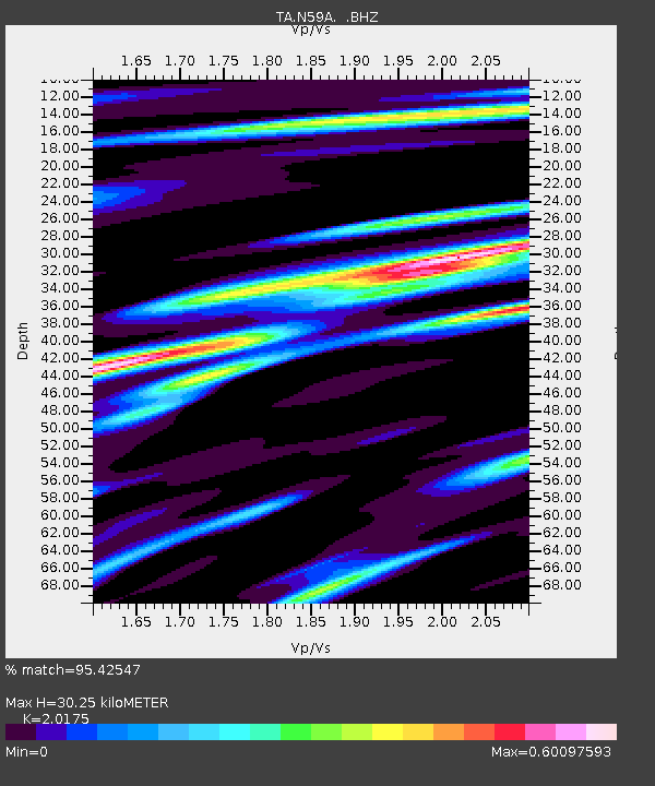
| Estimated Moho Depth: |
30.25 km |
| Estimated Crust Vp/Vs: |
2.02 |
| Assumed Crust Vp: |
6.283 km/s |
| Estimated Crust Vs: |
3.114 km/s |
| Estimated Crust Poisson's Ratio: |
0.34 |
|
| Radial Match: |
95.42547 % |
| Radial Bump: |
328 |
| Transverse Match: |
89.52114 % |
| Transverse Bump: |
400 |
| SOD ConfigId: |
414626 |
| Insert Time: |
2012-01-18 07:30:47.114 +0000 |
| GWidth: |
2.5 |
| Max Bumps: |
400 |
| Tol: |
0.001 |
|
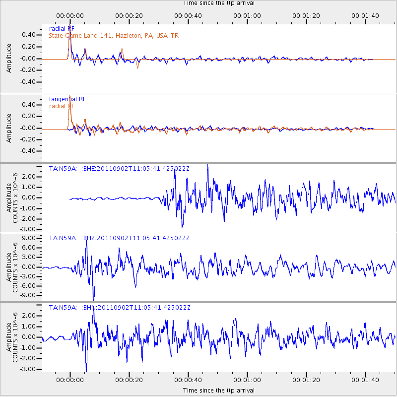
Signal To Noise
| Channel | StoN | STA | LTA |
| TA:N59A: :BHZ:20110902T11:05:41.425022Z | 15.308499 | 1.37268E-6 | 8.9667836E-8 |
| TA:N59A: :BHN:20110902T11:05:41.425022Z | 3.678055 | 4.643147E-7 | 1.2623919E-7 |
| TA:N59A: :BHE:20110902T11:05:41.425022Z | 6.769789 | 4.3198702E-7 | 6.3811E-8 |
| Arrivals |
| Ps | 5.1 SECOND |
| PpPs | 14 SECOND |
| PsPs/PpSs | 19 SECOND |


