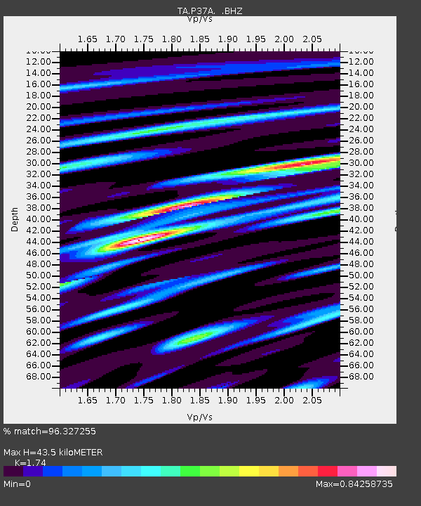
P37A Lathrop, MO, USA - Earthquake Result Viewer

Earthquake location: Fox Islands, Aleutian Islands
Earthquake latitude/longitude: 52.2/-171.7
Earthquake time(UTC): 2011/09/02 (245) 10:55:53 GMT
Earthquake Depth: 32 km
Earthquake Magnitude: 6.5 MB, 6.9 MS, 6.8 MW, 6.8 MW
Earthquake Catalog/Contributor: WHDF/NEIC
Network: TA USArray Transportable Network (new EarthScope stations)
Station: P37A Lathrop, MO, USA
Lat/Lon: 39.59 N/94.35 W
Elevation: 300 m
Distance: 52.8 deg
Az: 71.132 deg
Baz: 311.046 deg
Ray Param: 0.06644882
Estimated Moho Depth: 43.5 km
Estimated Crust Vp/Vs: 1.74
Assumed Crust Vp: 6.498 km/s
Estimated Crust Vs: 3.734 km/s
Estimated Crust Poisson's Ratio: 0.25
Radial Match: 96.327255 %
Radial Bump: 385
Transverse Match: 79.27267 %
Transverse Bump: 400
SOD ConfigId: 414626
Insert Time: 2012-01-18 07:31:58.769 +0000
GWidth: 2.5
Max Bumps: 400
Tol: 0.001

Signal To Noise

ChannelStoNSTALTA
TA:P37A: :BHZ:20110902T11:04:35.300022Z31.461113.65053E-61.1603311E-7
TA:P37A: :BHN:20110902T11:04:35.300022Z10.9581151.2045208E-61.0992044E-7
TA:P37A: :BHE:20110902T11:04:35.300022Z12.7537321.3658857E-61.07096945E-7
Arrivals
Ps5.2 SECOND
PpPs17 SECOND
PsPs/PpSs23 SECOND