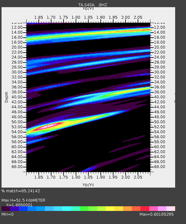
S40A Lebanon, MO, USA - Earthquake Result Viewer

Earthquake location: Fox Islands, Aleutian Islands
Earthquake latitude/longitude: 52.2/-171.7
Earthquake time(UTC): 2011/09/02 (245) 10:55:53 GMT
Earthquake Depth: 32 km
Earthquake Magnitude: 6.5 MB, 6.9 MS, 6.8 MW, 6.8 MW
Earthquake Catalog/Contributor: WHDF/NEIC
Network: TA USArray Transportable Network (new EarthScope stations)
Station: S40A Lebanon, MO, USA
Lat/Lon: 37.60 N/92.50 W
Elevation: 336 m
Distance: 55.2 deg
Az: 71.769 deg
Baz: 312.569 deg
Ray Param: 0.06487109
Estimated Moho Depth: 51.5 km
Estimated Crust Vp/Vs: 1.69
Assumed Crust Vp: 6.53 km/s
Estimated Crust Vs: 3.876 km/s
Estimated Crust Poisson's Ratio: 0.23
Radial Match: 85.24142 %
Radial Bump: 400
Transverse Match: 71.44369 %
Transverse Bump: 400
SOD ConfigId: 414626
Insert Time: 2012-01-18 07:33:23.648 +0000
GWidth: 2.5
Max Bumps: 400
Tol: 0.001

Signal To Noise

ChannelStoNSTALTA
TA:S40A: :BHZ:20110902T11:04:52.800022Z16.4121841.2787168E-67.791266E-8
TA:S40A: :BHN:20110902T11:04:52.800022Z6.17412044.373732E-77.083976E-8
TA:S40A: :BHE:20110902T11:04:52.800022Z4.706074.6882863E-79.962212E-8
Arrivals
Ps5.7 SECOND
PpPs20 SECOND
PsPs/PpSs26 SECOND