You are here: Home > Network List > TA - USArray Transportable Network (new EarthScope stations) Stations List
> Station 143A Socs Landing, Pioneer, LA, USA > Earthquake Result Viewer
143A Socs Landing, Pioneer, LA, USA - Earthquake Result Viewer

| Earthquake location: |
Fox Islands, Aleutian Islands |
| Earthquake latitude/longitude: |
52.2/-171.7 |
| Earthquake time(UTC): |
2011/09/02 (245) 10:55:53 GMT |
| Earthquake Depth: |
32 km |
| Earthquake Magnitude: |
6.5 MB, 6.9 MS, 6.8 MW, 6.8 MW |
| Earthquake Catalog/Contributor: |
WHDF/NEIC |
|
| Network: |
TA USArray Transportable Network (new EarthScope stations) |
| Station: |
143A Socs Landing, Pioneer, LA, USA |
| Lat/Lon: |
32.70 N/91.40 W |
| Elevation: |
30 m |
|
| Distance: |
59.3 deg |
| Az: |
75.218 deg |
| Baz: |
315.066 deg |
| Ray Param: |
0.062248778 |
| Estimated Moho Depth: |
12.0 km |
| Estimated Crust Vp/Vs: |
1.60 |
| Assumed Crust Vp: |
6.201 km/s |
| Estimated Crust Vs: |
3.876 km/s |
| Estimated Crust Poisson's Ratio: |
0.18 |
|
| Radial Match: |
95.10486 % |
| Radial Bump: |
378 |
| Transverse Match: |
92.45641 % |
| Transverse Bump: |
400 |
| SOD ConfigId: |
414626 |
| Insert Time: |
2012-01-18 07:36:05.387 +0000 |
| GWidth: |
2.5 |
| Max Bumps: |
400 |
| Tol: |
0.001 |
|
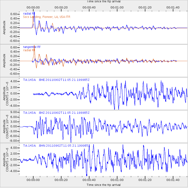
Signal To Noise
| Channel | StoN | STA | LTA |
| TA:143A: :BHZ:20110902T11:05:21.199985Z | 23.74198 | 2.8342777E-6 | 1.1937831E-7 |
| TA:143A: :BHN:20110902T11:05:21.199985Z | 2.6051006 | 8.719235E-7 | 3.3469857E-7 |
| TA:143A: :BHE:20110902T11:05:21.199985Z | 3.2944658 | 7.9010584E-7 | 2.398282E-7 |
| Arrivals |
| Ps | 1.2 SECOND |
| PpPs | 4.8 SECOND |
| PsPs/PpSs | 6.0 SECOND |


