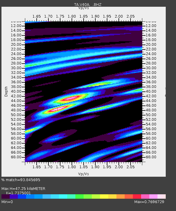
V40A Witts Springs, AR, USA - Earthquake Result Viewer
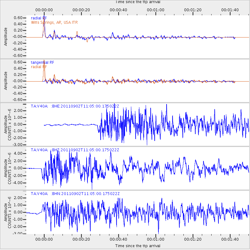
Earthquake location: Fox Islands, Aleutian Islands
Earthquake latitude/longitude: 52.2/-171.7
Earthquake time(UTC): 2011/09/02 (245) 10:55:53 GMT
Earthquake Depth: 32 km
Earthquake Magnitude: 6.5 MB, 6.9 MS, 6.8 MW, 6.8 MW
Earthquake Catalog/Contributor: WHDF/NEIC
Network: TA USArray Transportable Network (new EarthScope stations)
Station: V40A Witts Springs, AR, USA
Lat/Lon: 35.80 N/92.82 W
Elevation: 570 m
Distance: 56.3 deg
Az: 73.568 deg
Baz: 313.389 deg
Ray Param: 0.064199716
Estimated Moho Depth: 47.25 km
Estimated Crust Vp/Vs: 1.74
Assumed Crust Vp: 6.498 km/s
Estimated Crust Vs: 3.74 km/s
Estimated Crust Poisson's Ratio: 0.25
Radial Match: 93.845695 %
Radial Bump: 400
Transverse Match: 74.01198 %
Transverse Bump: 400
SOD ConfigId: 414626
Insert Time: 2012-01-18 07:36:38.459 +0000
GWidth: 2.5
Max Bumps: 400
Tol: 0.001

Signal To Noise

ChannelStoNSTALTA
TA:V40A: :BHZ:20110902T11:05:00.175022Z36.3944172.2949318E-66.305725E-8
TA:V40A: :BHN:20110902T11:05:00.175022Z12.96095859.4356176E-77.280031E-8
TA:V40A: :BHE:20110902T11:05:00.175022Z19.404471.0545176E-65.4344056E-8
Arrivals
Ps5.7 SECOND
PpPs19 SECOND
PsPs/PpSs25 SECOND