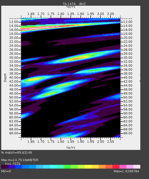
147A Livingston, AL, USA - Earthquake Result Viewer

Earthquake location: Fox Islands, Aleutian Islands
Earthquake latitude/longitude: 52.2/-171.7
Earthquake time(UTC): 2011/09/02 (245) 10:55:53 GMT
Earthquake Depth: 32 km
Earthquake Magnitude: 6.5 MB, 6.9 MS, 6.8 MW, 6.8 MW
Earthquake Catalog/Contributor: WHDF/NEIC
Network: TA USArray Transportable Network (new EarthScope stations)
Station: 147A Livingston, AL, USA
Lat/Lon: 32.67 N/88.27 W
Elevation: 57 m
Distance: 61.1 deg
Az: 73.075 deg
Baz: 315.685 deg
Ray Param: 0.061014287
Estimated Moho Depth: 14.75 km
Estimated Crust Vp/Vs: 1.70
Assumed Crust Vp: 6.201 km/s
Estimated Crust Vs: 3.643 km/s
Estimated Crust Poisson's Ratio: 0.24
Radial Match: 95.63148 %
Radial Bump: 400
Transverse Match: 90.98918 %
Transverse Bump: 400
SOD ConfigId: 414626
Insert Time: 2012-01-18 07:39:52.632 +0000
GWidth: 2.5
Max Bumps: 400
Tol: 0.001

Signal To Noise

ChannelStoNSTALTA
TA:147A: :BHZ:20110902T11:05:34.024998Z32.31155.40664E-61.6732865E-7
TA:147A: :BHN:20110902T11:05:34.024998Z4.43044479.113701E-72.0570624E-7
TA:147A: :BHE:20110902T11:05:34.024998Z5.34787131.0326174E-61.9308943E-7
Arrivals
Ps1.7 SECOND
PpPs6.1 SECOND
PsPs/PpSs7.9 SECOND