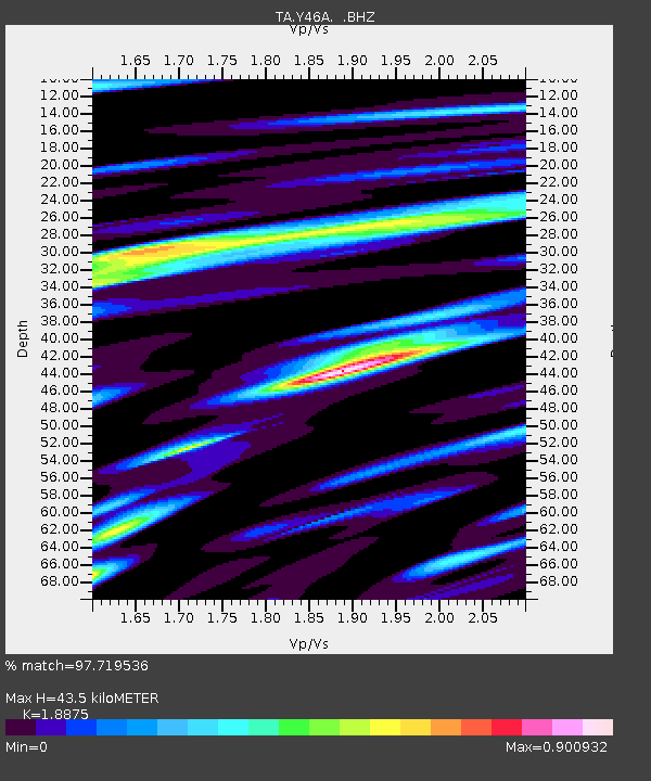
Y46A Houston, MS, USA - Earthquake Result Viewer

Earthquake location: Fox Islands, Aleutian Islands
Earthquake latitude/longitude: 52.2/-171.7
Earthquake time(UTC): 2011/09/02 (245) 10:55:53 GMT
Earthquake Depth: 32 km
Earthquake Magnitude: 6.5 MB, 6.9 MS, 6.8 MW, 6.8 MW
Earthquake Catalog/Contributor: WHDF/NEIC
Network: TA USArray Transportable Network (new EarthScope stations)
Station: Y46A Houston, MS, USA
Lat/Lon: 33.88 N/88.86 W
Elevation: 109 m
Distance: 59.9 deg
Az: 72.505 deg
Baz: 315.084 deg
Ray Param: 0.061807595
Estimated Moho Depth: 43.5 km
Estimated Crust Vp/Vs: 1.89
Assumed Crust Vp: 6.201 km/s
Estimated Crust Vs: 3.286 km/s
Estimated Crust Poisson's Ratio: 0.30
Radial Match: 97.719536 %
Radial Bump: 308
Transverse Match: 94.05873 %
Transverse Bump: 400
SOD ConfigId: 414626
Insert Time: 2012-01-18 07:40:12.300 +0000
GWidth: 2.5
Max Bumps: 400
Tol: 0.001

Signal To Noise

ChannelStoNSTALTA
TA:Y46A: :BHZ:20110902T11:05:25.824985Z70.611764.518672E-66.399319E-8
TA:Y46A: :BHN:20110902T11:05:25.824985Z13.3447031.5373151E-61.152004E-7
TA:Y46A: :BHE:20110902T11:05:25.824985Z18.4360451.6074691E-68.7191644E-8
Arrivals
Ps6.5 SECOND
PpPs19 SECOND
PsPs/PpSs26 SECOND