You are here: Home > Network List > TA - USArray Transportable Network (new EarthScope stations) Stations List
> Station Z44A Pea Ridge, Belzoni, MS, USA > Earthquake Result Viewer
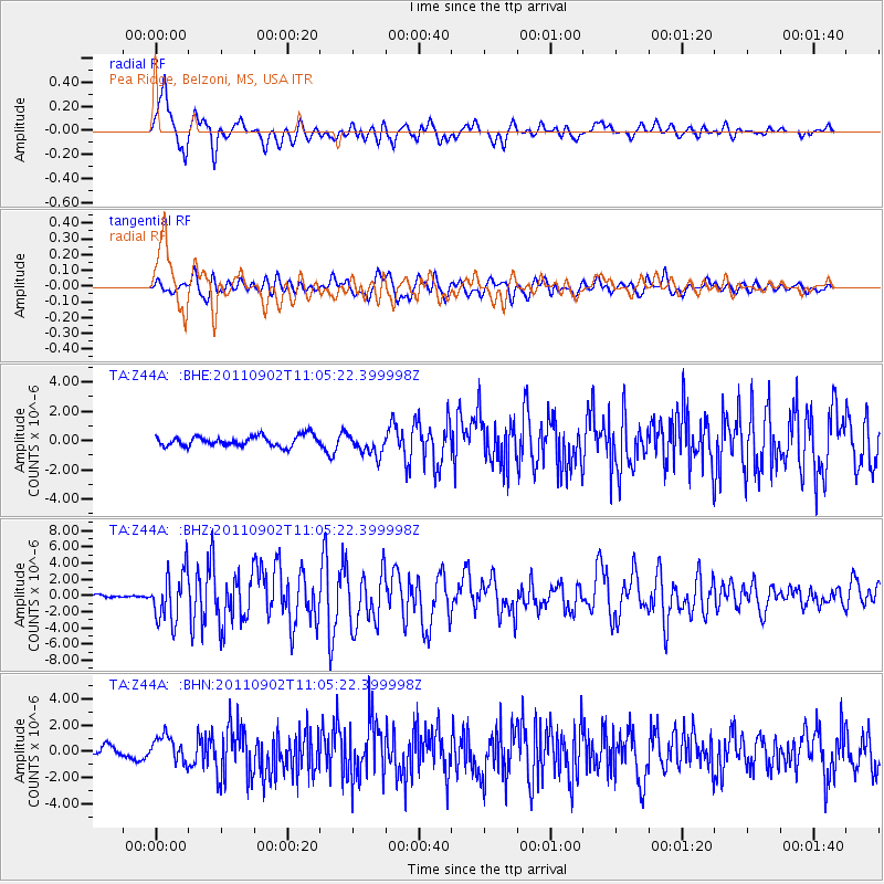
Z44A Pea Ridge, Belzoni, MS, USA - Earthquake Result Viewer
*The percent match for this event was below the threshold and hence no stack was calculated.
| Earthquake location: |
Fox Islands, Aleutian Islands |
| Earthquake latitude/longitude: |
52.2/-171.7 |
| Earthquake time(UTC): |
2011/09/02 (245) 10:55:53 GMT |
| Earthquake Depth: |
32 km |
| Earthquake Magnitude: |
6.5 MB, 6.9 MS, 6.8 MW, 6.8 MW |
| Earthquake Catalog/Contributor: |
WHDF/NEIC |
|
| Network: |
TA USArray Transportable Network (new EarthScope stations) |
| Station: |
Z44A Pea Ridge, Belzoni, MS, USA |
| Lat/Lon: |
33.28 N/90.43 W |
| Elevation: |
39 m |
|
| Distance: |
59.4 deg |
| Az: |
74.076 deg |
| Baz: |
315.01 deg |
| Ray Param: |
$rayparam |
*The percent match for this event was below the threshold and hence was not used in the summary stack. |
|
| Radial Match: |
87.26143 % |
| Radial Bump: |
400 |
| Transverse Match: |
66.930244 % |
| Transverse Bump: |
400 |
| SOD ConfigId: |
414626 |
| Insert Time: |
2012-01-18 07:40:30.248 +0000 |
| GWidth: |
2.5 |
| Max Bumps: |
400 |
| Tol: |
0.001 |
|
Signal To Noise
| Channel | StoN | STA | LTA |
| TA:Z44A: :BHZ:20110902T11:05:22.399998Z | 19.040743 | 3.0478618E-6 | 1.6007053E-7 |
| TA:Z44A: :BHN:20110902T11:05:22.399998Z | 2.9829693 | 1.0055032E-6 | 3.370813E-7 |
| TA:Z44A: :BHE:20110902T11:05:22.399998Z | 2.0825574 | 7.426724E-7 | 3.5661557E-7 |
| Arrivals |
| Ps | |
| PpPs | |
| PsPs/PpSs | |


