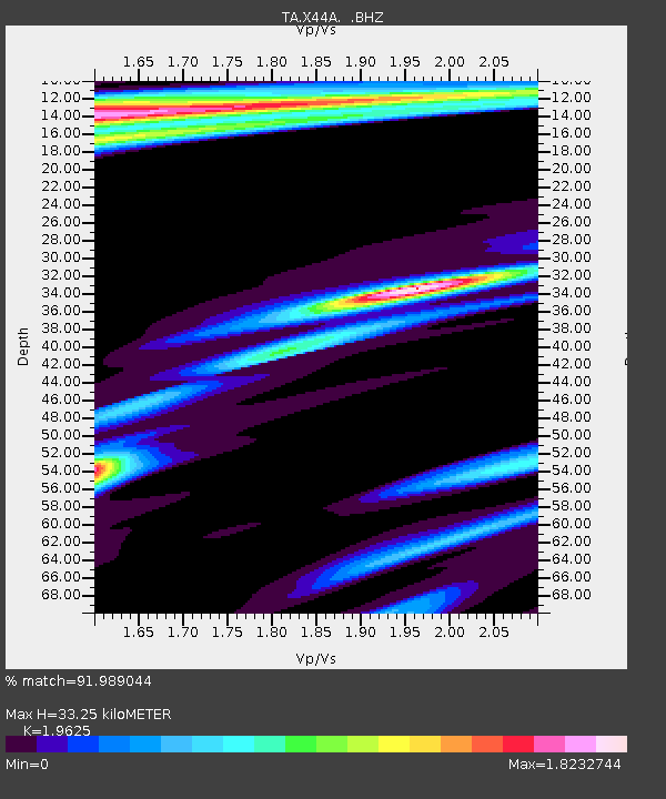
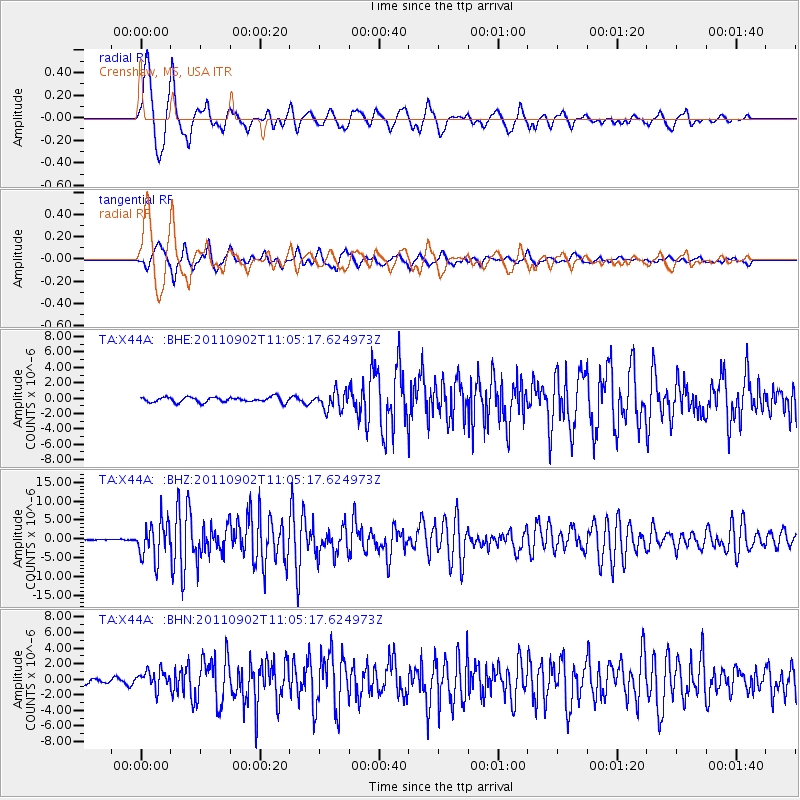
X44A Crenshaw, MS, USA - Earthquake Result Viewer

Earthquake location: Fox Islands, Aleutian Islands
Earthquake latitude/longitude: 52.2/-171.7
Earthquake time(UTC): 2011/09/02 (245) 10:55:53 GMT
Earthquake Depth: 32 km
Earthquake Magnitude: 6.5 MB, 6.9 MS, 6.8 MW, 6.8 MW
Earthquake Catalog/Contributor: WHDF/NEIC
Network: TA USArray Transportable Network (new EarthScope stations)
Station: X44A Crenshaw, MS, USA
Lat/Lon: 34.50 N/90.15 W
Elevation: 109 m
Distance: 58.7 deg
Az: 72.872 deg
Baz: 314.55 deg
Ray Param: 0.062589504
Estimated Moho Depth: 33.25 km
Estimated Crust Vp/Vs: 1.96
Assumed Crust Vp: 6.273 km/s
Estimated Crust Vs: 3.197 km/s
Estimated Crust Poisson's Ratio: 0.32
Radial Match: 91.989044 %
Radial Bump: 400
Transverse Match: 86.60709 %
Transverse Bump: 400
SOD ConfigId: 414626
Insert Time: 2012-01-18 07:41:43.228 +0000
GWidth: 2.5
Max Bumps: 400
Tol: 0.001

Signal To Noise

ChannelStoNSTALTA
TA:X44A: :BHZ:20110902T11:05:17.624973Z39.9416584.8617085E-61.2172025E-7
TA:X44A: :BHN:20110902T11:05:17.624973Z3.34628841.1545994E-63.4503884E-7
TA:X44A: :BHE:20110902T11:05:17.624973Z3.50622651.1790459E-63.3627202E-7
Arrivals
Ps5.3 SECOND
PpPs15 SECOND
PsPs/PpSs20 SECOND