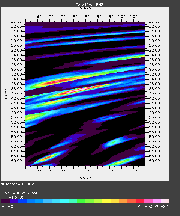
V42A Cord, AR, USA - Earthquake Result Viewer

Earthquake location: Fox Islands, Aleutian Islands
Earthquake latitude/longitude: 52.2/-171.7
Earthquake time(UTC): 2011/09/02 (245) 10:55:53 GMT
Earthquake Depth: 32 km
Earthquake Magnitude: 6.5 MB, 6.9 MS, 6.8 MW, 6.8 MW
Earthquake Catalog/Contributor: WHDF/NEIC
Network: TA USArray Transportable Network (new EarthScope stations)
Station: V42A Cord, AR, USA
Lat/Lon: 35.81 N/91.39 W
Elevation: 134 m
Distance: 57.1 deg
Az: 72.606 deg
Baz: 313.696 deg
Ray Param: 0.06364751
Estimated Moho Depth: 38.25 km
Estimated Crust Vp/Vs: 1.82
Assumed Crust Vp: 6.273 km/s
Estimated Crust Vs: 3.442 km/s
Estimated Crust Poisson's Ratio: 0.28
Radial Match: 92.90238 %
Radial Bump: 400
Transverse Match: 84.279755 %
Transverse Bump: 400
SOD ConfigId: 414626
Insert Time: 2012-01-18 07:42:16.479 +0000
GWidth: 2.5
Max Bumps: 400
Tol: 0.001

Signal To Noise

ChannelStoNSTALTA
TA:V42A: :BHZ:20110902T11:05:06.149998Z17.3296721.8376157E-61.060387E-7
TA:V42A: :BHN:20110902T11:05:06.149998Z11.3841847.0799604E-76.21912E-8
TA:V42A: :BHE:20110902T11:05:06.149998Z10.3378427.396721E-77.1549955E-8
Arrivals
Ps5.3 SECOND
PpPs16 SECOND
PsPs/PpSs22 SECOND