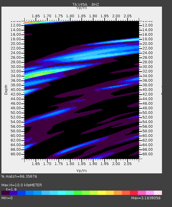
V45A Humboldt, TN, USA - Earthquake Result Viewer
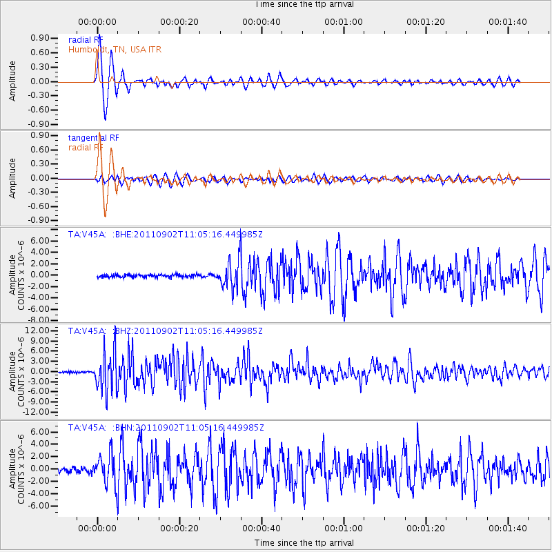
Earthquake location: Fox Islands, Aleutian Islands
Earthquake latitude/longitude: 52.2/-171.7
Earthquake time(UTC): 2011/09/02 (245) 10:55:53 GMT
Earthquake Depth: 32 km
Earthquake Magnitude: 6.5 MB, 6.9 MS, 6.8 MW, 6.8 MW
Earthquake Catalog/Contributor: WHDF/NEIC
Network: TA USArray Transportable Network (new EarthScope stations)
Station: V45A Humboldt, TN, USA
Lat/Lon: 35.74 N/88.96 W
Elevation: 126 m
Distance: 58.6 deg
Az: 71.04 deg
Baz: 314.277 deg
Ray Param: 0.06270087
Estimated Moho Depth: 10.0 km
Estimated Crust Vp/Vs: 1.60
Assumed Crust Vp: 6.38 km/s
Estimated Crust Vs: 3.988 km/s
Estimated Crust Poisson's Ratio: 0.18
Radial Match: 96.35976 %
Radial Bump: 361
Transverse Match: 84.78177 %
Transverse Bump: 400
SOD ConfigId: 414626
Insert Time: 2012-01-18 07:42:32.450 +0000
GWidth: 2.5
Max Bumps: 400
Tol: 0.001

Signal To Noise

ChannelStoNSTALTA
TA:V45A: :BHZ:20110902T11:05:16.449985Z34.792515.9358977E-61.7060847E-7
TA:V45A: :BHN:20110902T11:05:16.449985Z6.05552242.5289219E-64.176224E-7
TA:V45A: :BHE:20110902T11:05:16.449985Z11.0756192.4805202E-62.239622E-7
Arrivals
Ps1.0 SECOND
PpPs3.9 SECOND
PsPs/PpSs4.9 SECOND