X43A Marvell, AR, USA - Earthquake Result Viewer
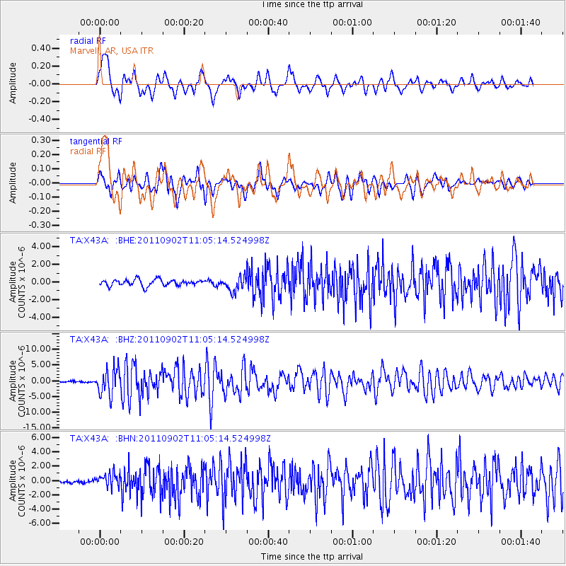
Earthquake location: Fox Islands, Aleutian Islands
Earthquake latitude/longitude: 52.2/-171.7
Earthquake time(UTC): 2011/09/02 (245) 10:55:53 GMT
Earthquake Depth: 32 km
Earthquake Magnitude: 6.5 MB, 6.9 MS, 6.8 MW, 6.8 MW
Earthquake Catalog/Contributor: WHDF/NEIC
Network: TA USArray Transportable Network (new EarthScope stations)
Station: X43A Marvell, AR, USA
Lat/Lon: 34.52 N/90.88 W
Elevation: 53 m
Distance: 58.3 deg
Az: 73.356 deg
Baz: 314.388 deg
Ray Param: 0.06287987
Estimated Moho Depth: 20.25 km
Estimated Crust Vp/Vs: 1.60
Assumed Crust Vp: 6.273 km/s
Estimated Crust Vs: 3.921 km/s
Estimated Crust Poisson's Ratio: 0.18
Radial Match: 89.636734 %
Radial Bump: 400
Transverse Match: 80.529945 %
Transverse Bump: 400
SOD ConfigId: 414626
Insert Time: 2012-01-18 07:42:54.605 +0000
GWidth: 2.5
Max Bumps: 400
Tol: 0.001

Signal To Noise

ChannelStoNSTALTA
TA:X43A: :BHZ:20110902T11:05:14.524998Z23.4551774.1405583E-61.7653068E-7
TA:X43A: :BHN:20110902T11:05:14.524998Z3.2916099.531504E-72.8956973E-7
TA:X43A: :BHE:20110902T11:05:14.524998Z2.38534678.542749E-73.5813449E-7
Arrivals
Ps2.0 SECOND
PpPs8.0 SECOND
PsPs/PpSs10 SECOND