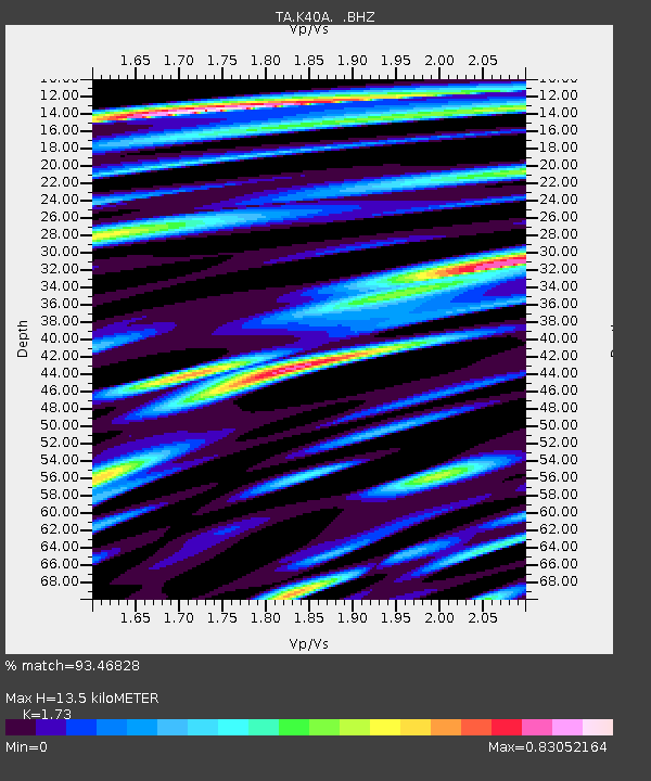
K40A Colesburg, IA, USA - Earthquake Result Viewer
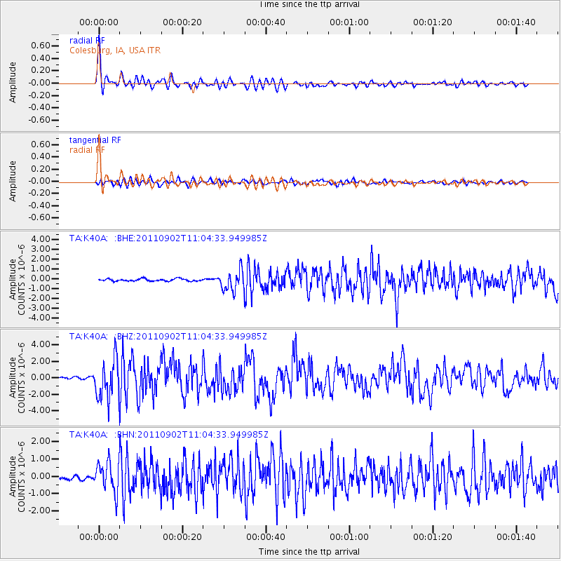
Earthquake location: Fox Islands, Aleutian Islands
Earthquake latitude/longitude: 52.2/-171.7
Earthquake time(UTC): 2011/09/02 (245) 10:55:53 GMT
Earthquake Depth: 32 km
Earthquake Magnitude: 6.5 MB, 6.9 MS, 6.8 MW, 6.8 MW
Earthquake Catalog/Contributor: WHDF/NEIC
Network: TA USArray Transportable Network (new EarthScope stations)
Station: K40A Colesburg, IA, USA
Lat/Lon: 42.70 N/91.14 W
Elevation: 274 m
Distance: 52.6 deg
Az: 66.184 deg
Baz: 310.155 deg
Ray Param: 0.06656842
Estimated Moho Depth: 13.5 km
Estimated Crust Vp/Vs: 1.73
Assumed Crust Vp: 6.53 km/s
Estimated Crust Vs: 3.775 km/s
Estimated Crust Poisson's Ratio: 0.25
Radial Match: 93.46828 %
Radial Bump: 400
Transverse Match: 82.41472 %
Transverse Bump: 400
SOD ConfigId: 414626
Insert Time: 2012-01-18 07:44:11.254 +0000
GWidth: 2.5
Max Bumps: 400
Tol: 0.001

Signal To Noise

ChannelStoNSTALTA
TA:K40A: :BHZ:20110902T11:04:33.949985Z26.1323342.416046E-69.245428E-8
TA:K40A: :BHN:20110902T11:04:33.949985Z11.0452149.006089E-78.153838E-8
TA:K40A: :BHE:20110902T11:04:33.949985Z8.9382961.0616718E-61.1877787E-7
Arrivals
Ps1.6 SECOND
PpPs5.3 SECOND
PsPs/PpSs6.9 SECOND