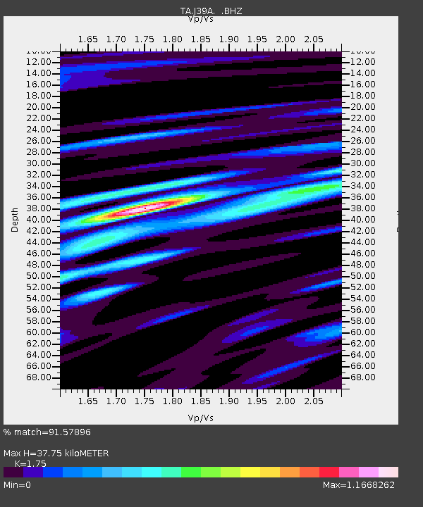
J39A Decorah, IA, USA - Earthquake Result Viewer

Earthquake location: Fox Islands, Aleutian Islands
Earthquake latitude/longitude: 52.2/-171.7
Earthquake time(UTC): 2011/09/02 (245) 10:55:53 GMT
Earthquake Depth: 32 km
Earthquake Magnitude: 6.5 MB, 6.9 MS, 6.8 MW, 6.8 MW
Earthquake Catalog/Contributor: WHDF/NEIC
Network: TA USArray Transportable Network (new EarthScope stations)
Station: J39A Decorah, IA, USA
Lat/Lon: 43.34 N/91.71 W
Elevation: 350 m
Distance: 51.9 deg
Az: 65.905 deg
Baz: 309.598 deg
Ray Param: 0.06703592
Estimated Moho Depth: 37.75 km
Estimated Crust Vp/Vs: 1.75
Assumed Crust Vp: 6.53 km/s
Estimated Crust Vs: 3.732 km/s
Estimated Crust Poisson's Ratio: 0.26
Radial Match: 91.57896 %
Radial Bump: 400
Transverse Match: 80.81012 %
Transverse Bump: 400
SOD ConfigId: 414626
Insert Time: 2012-01-18 07:44:18.453 +0000
GWidth: 2.5
Max Bumps: 400
Tol: 0.001

Signal To Noise

ChannelStoNSTALTA
TA:J39A: :BHZ:20110902T11:04:28.574985Z32.0644263.5331877E-61.1019027E-7
TA:J39A: :BHN:20110902T11:04:28.574985Z10.3450731.027711E-69.934305E-8
TA:J39A: :BHE:20110902T11:04:28.574985Z23.8930111.6912472E-67.078418E-8
Arrivals
Ps4.6 SECOND
PpPs15 SECOND
PsPs/PpSs20 SECOND