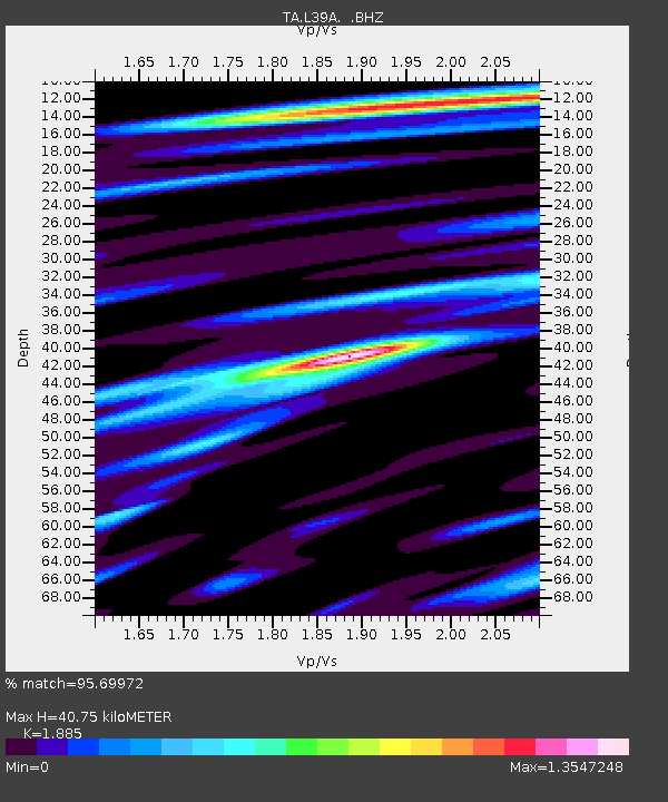
L39A Vinton, IA, USA - Earthquake Result Viewer
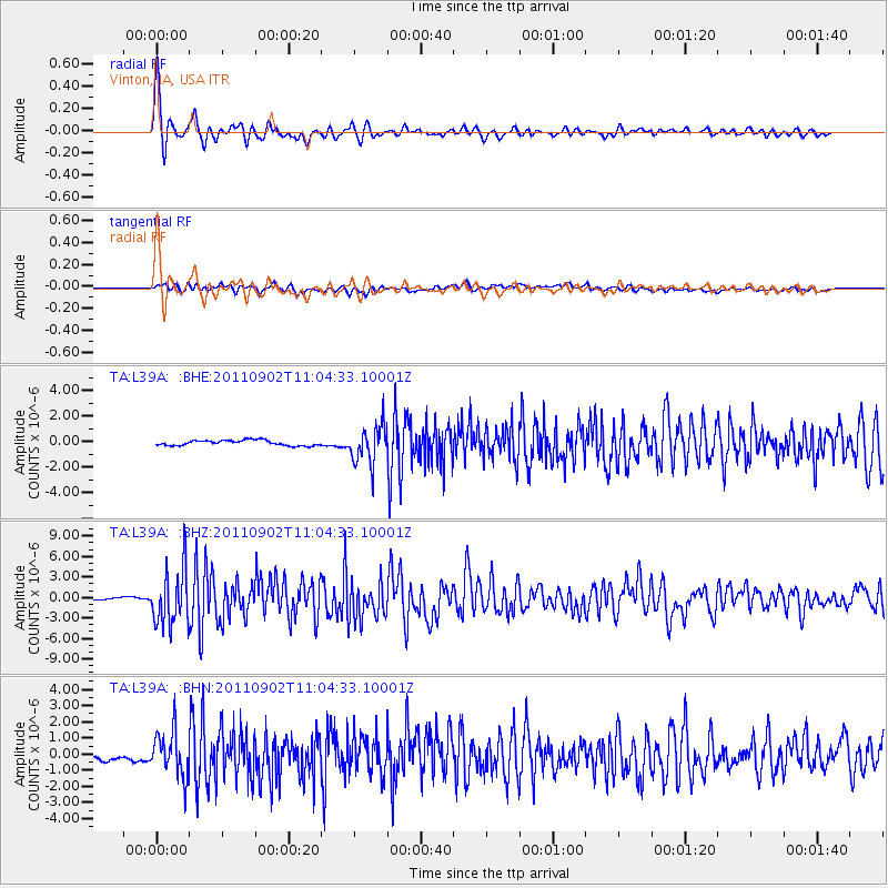
Earthquake location: Fox Islands, Aleutian Islands
Earthquake latitude/longitude: 52.2/-171.7
Earthquake time(UTC): 2011/09/02 (245) 10:55:53 GMT
Earthquake Depth: 32 km
Earthquake Magnitude: 6.5 MB, 6.9 MS, 6.8 MW, 6.8 MW
Earthquake Catalog/Contributor: WHDF/NEIC
Network: TA USArray Transportable Network (new EarthScope stations)
Station: L39A Vinton, IA, USA
Lat/Lon: 42.12 N/92.00 W
Elevation: 261 m
Distance: 52.5 deg
Az: 67.257 deg
Baz: 310.227 deg
Ray Param: 0.06664261
Estimated Moho Depth: 40.75 km
Estimated Crust Vp/Vs: 1.88
Assumed Crust Vp: 6.53 km/s
Estimated Crust Vs: 3.464 km/s
Estimated Crust Poisson's Ratio: 0.30
Radial Match: 95.69972 %
Radial Bump: 400
Transverse Match: 75.2712 %
Transverse Bump: 400
SOD ConfigId: 414626
Insert Time: 2012-01-18 07:44:28.647 +0000
GWidth: 2.5
Max Bumps: 400
Tol: 0.001

Signal To Noise

ChannelStoNSTALTA
TA:L39A: :BHZ:20110902T11:04:33.10001Z27.8876534.157814E-61.4909158E-7
TA:L39A: :BHN:20110902T11:04:33.10001Z7.3321871.3599252E-61.8547335E-7
TA:L39A: :BHE:20110902T11:04:33.10001Z7.0005221.4498172E-62.071013E-7
Arrivals
Ps5.8 SECOND
PpPs17 SECOND
PsPs/PpSs23 SECOND