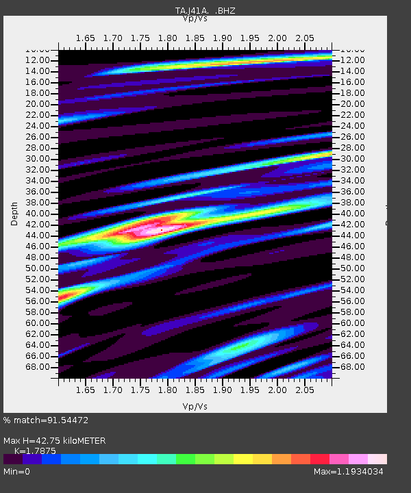
J41A Loganville, WI, USA - Earthquake Result Viewer

Earthquake location: Fox Islands, Aleutian Islands
Earthquake latitude/longitude: 52.2/-171.7
Earthquake time(UTC): 2011/09/02 (245) 10:55:53 GMT
Earthquake Depth: 32 km
Earthquake Magnitude: 6.5 MB, 6.9 MS, 6.8 MW, 6.8 MW
Earthquake Catalog/Contributor: WHDF/NEIC
Network: TA USArray Transportable Network (new EarthScope stations)
Station: J41A Loganville, WI, USA
Lat/Lon: 43.37 N/90.01 W
Elevation: 360 m
Distance: 52.8 deg
Az: 64.877 deg
Baz: 310.128 deg
Ray Param: 0.066435345
Estimated Moho Depth: 42.75 km
Estimated Crust Vp/Vs: 1.79
Assumed Crust Vp: 6.53 km/s
Estimated Crust Vs: 3.653 km/s
Estimated Crust Poisson's Ratio: 0.27
Radial Match: 91.54472 %
Radial Bump: 400
Transverse Match: 81.28629 %
Transverse Bump: 400
SOD ConfigId: 414626
Insert Time: 2012-01-18 07:44:44.841 +0000
GWidth: 2.5
Max Bumps: 400
Tol: 0.001

Signal To Noise

ChannelStoNSTALTA
TA:J41A: :BHZ:20110902T11:04:35.449985Z18.0578652.546344E-61.4101025E-7
TA:J41A: :BHN:20110902T11:04:35.449985Z8.6827097.315496E-78.425362E-8
TA:J41A: :BHE:20110902T11:04:35.449985Z19.2845611.3101497E-66.7937755E-8
Arrivals
Ps5.5 SECOND
PpPs17 SECOND
PsPs/PpSs23 SECOND