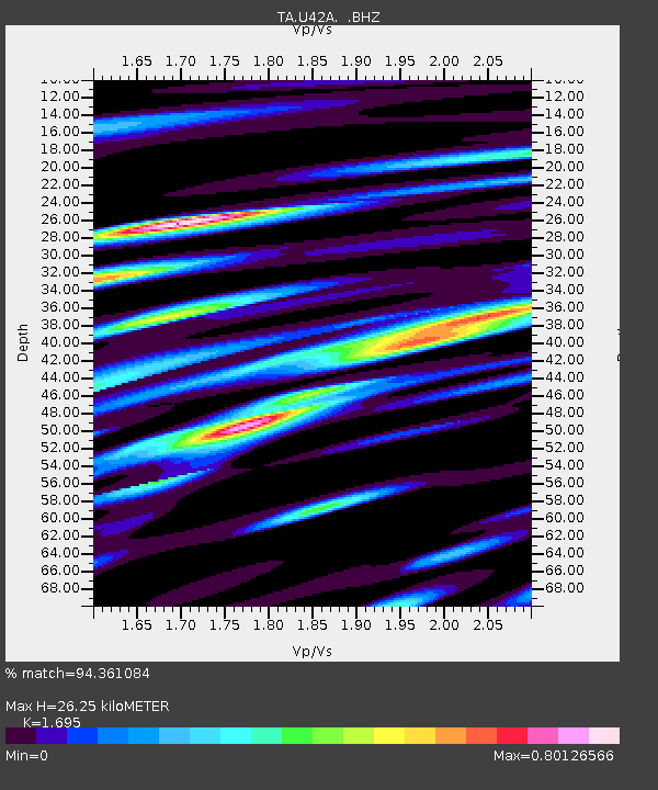
U42A Revenden, AR, USA - Earthquake Result Viewer
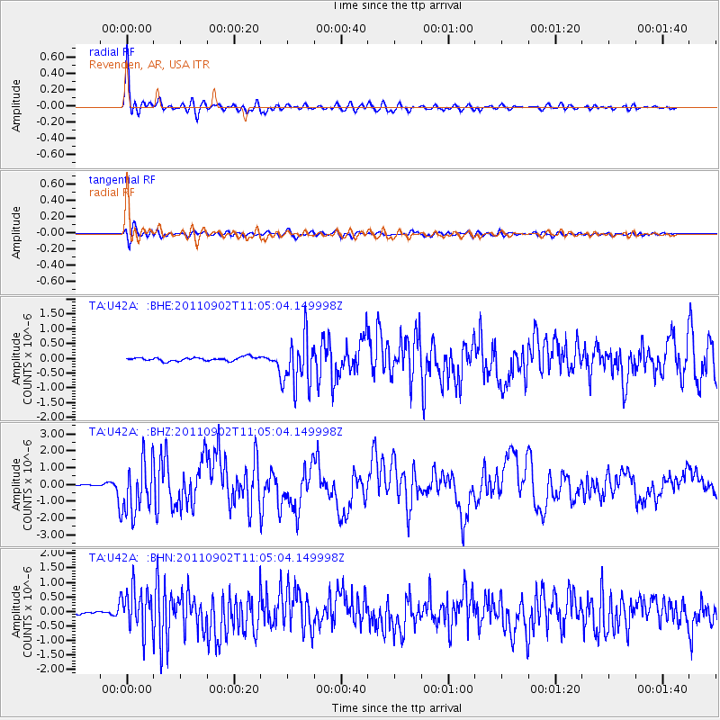
Earthquake location: Fox Islands, Aleutian Islands
Earthquake latitude/longitude: 52.2/-171.7
Earthquake time(UTC): 2011/09/02 (245) 10:55:53 GMT
Earthquake Depth: 32 km
Earthquake Magnitude: 6.5 MB, 6.9 MS, 6.8 MW, 6.8 MW
Earthquake Catalog/Contributor: WHDF/NEIC
Network: TA USArray Transportable Network (new EarthScope stations)
Station: U42A Revenden, AR, USA
Lat/Lon: 36.35 N/91.24 W
Elevation: 119 m
Distance: 56.8 deg
Az: 72.034 deg
Baz: 313.473 deg
Ray Param: 0.06383522
Estimated Moho Depth: 26.25 km
Estimated Crust Vp/Vs: 1.70
Assumed Crust Vp: 6.53 km/s
Estimated Crust Vs: 3.853 km/s
Estimated Crust Poisson's Ratio: 0.23
Radial Match: 94.361084 %
Radial Bump: 400
Transverse Match: 80.12662 %
Transverse Bump: 400
SOD ConfigId: 414626
Insert Time: 2012-01-18 07:45:38.104 +0000
GWidth: 2.5
Max Bumps: 400
Tol: 0.001

Signal To Noise

ChannelStoNSTALTA
TA:U42A: :BHZ:20110902T11:05:04.149998Z19.7689111.5521208E-67.851322E-8
TA:U42A: :BHN:20110902T11:05:04.149998Z11.622757.2681524E-76.253384E-8
TA:U42A: :BHE:20110902T11:05:04.149998Z14.0530648.711183E-76.1987784E-8
Arrivals
Ps3.0 SECOND
PpPs10 SECOND
PsPs/PpSs13 SECOND