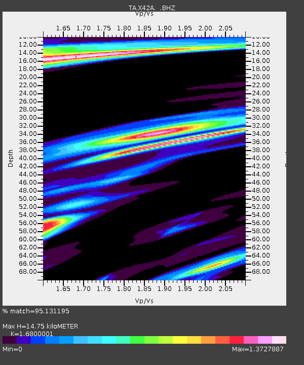
X42A Stuttgart, AR, USA - Earthquake Result Viewer

Earthquake location: Fox Islands, Aleutian Islands
Earthquake latitude/longitude: 52.2/-171.7
Earthquake time(UTC): 2011/09/02 (245) 10:55:53 GMT
Earthquake Depth: 32 km
Earthquake Magnitude: 6.5 MB, 6.9 MS, 6.8 MW, 6.8 MW
Earthquake Catalog/Contributor: WHDF/NEIC
Network: TA USArray Transportable Network (new EarthScope stations)
Station: X42A Stuttgart, AR, USA
Lat/Lon: 34.55 N/91.63 W
Elevation: 62 m
Distance: 57.8 deg
Az: 73.832 deg
Baz: 314.22 deg
Ray Param: 0.06318247
Estimated Moho Depth: 14.75 km
Estimated Crust Vp/Vs: 1.68
Assumed Crust Vp: 6.273 km/s
Estimated Crust Vs: 3.734 km/s
Estimated Crust Poisson's Ratio: 0.23
Radial Match: 95.131195 %
Radial Bump: 400
Transverse Match: 88.71831 %
Transverse Bump: 400
SOD ConfigId: 414626
Insert Time: 2012-01-18 07:46:48.133 +0000
GWidth: 2.5
Max Bumps: 400
Tol: 0.001

Signal To Noise

ChannelStoNSTALTA
TA:X42A: :BHZ:20110902T11:05:11.274998Z13.8916674.02338E-62.896254E-7
TA:X42A: :BHN:20110902T11:05:11.274998Z3.73801521.8131852E-64.850663E-7
TA:X42A: :BHE:20110902T11:05:11.274998Z1.91256581.0749301E-65.6203555E-7
Arrivals
Ps1.7 SECOND
PpPs6.0 SECOND
PsPs/PpSs7.7 SECOND