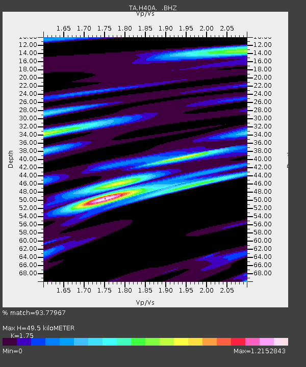
H40A Chili, WI, USA - Earthquake Result Viewer
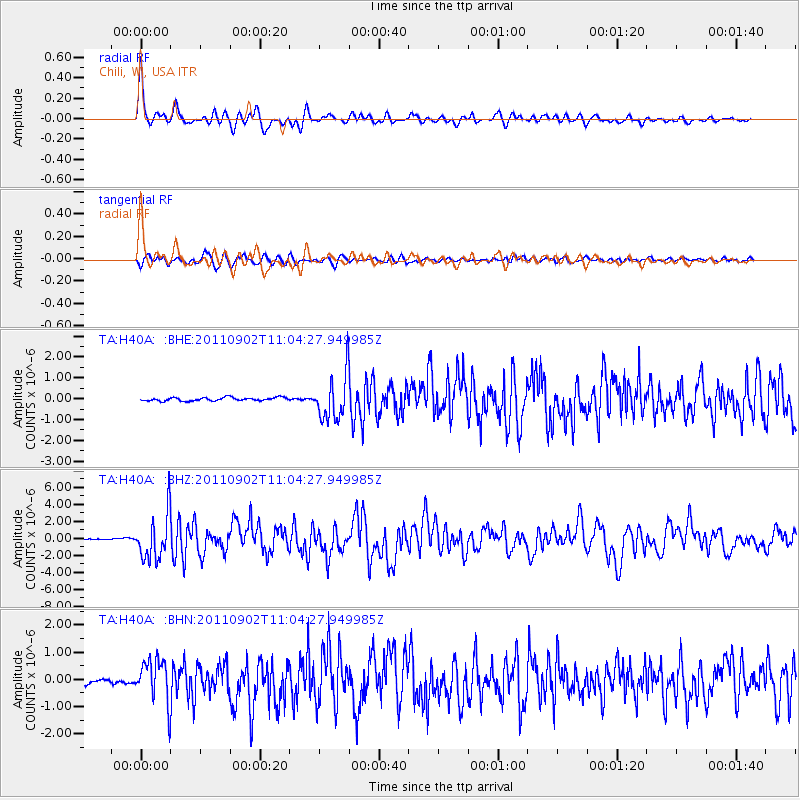
Earthquake location: Fox Islands, Aleutian Islands
Earthquake latitude/longitude: 52.2/-171.7
Earthquake time(UTC): 2011/09/02 (245) 10:55:53 GMT
Earthquake Depth: 32 km
Earthquake Magnitude: 6.5 MB, 6.9 MS, 6.8 MW, 6.8 MW
Earthquake Catalog/Contributor: WHDF/NEIC
Network: TA USArray Transportable Network (new EarthScope stations)
Station: H40A Chili, WI, USA
Lat/Lon: 44.62 N/90.39 W
Elevation: 372 m
Distance: 51.8 deg
Az: 63.876 deg
Baz: 309.256 deg
Ray Param: 0.06709117
Estimated Moho Depth: 49.5 km
Estimated Crust Vp/Vs: 1.75
Assumed Crust Vp: 6.571 km/s
Estimated Crust Vs: 3.755 km/s
Estimated Crust Poisson's Ratio: 0.26
Radial Match: 93.77967 %
Radial Bump: 373
Transverse Match: 85.74377 %
Transverse Bump: 400
SOD ConfigId: 414626
Insert Time: 2012-01-18 07:47:22.617 +0000
GWidth: 2.5
Max Bumps: 400
Tol: 0.001

Signal To Noise

ChannelStoNSTALTA
TA:H40A: :BHZ:20110902T11:04:27.949985Z52.9480672.6634175E-65.030245E-8
TA:H40A: :BHN:20110902T11:04:27.949985Z9.73123557.6826825E-77.894869E-8
TA:H40A: :BHE:20110902T11:04:27.949985Z13.2219411.0883887E-68.231686E-8
Arrivals
Ps6.0 SECOND
PpPs20 SECOND
PsPs/PpSs26 SECOND