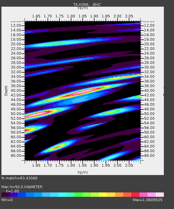
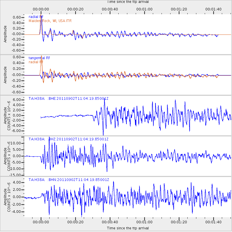
H38A Maiden Rock, WI, USA - Earthquake Result Viewer

Earthquake location: Fox Islands, Aleutian Islands
Earthquake latitude/longitude: 52.2/-171.7
Earthquake time(UTC): 2011/09/02 (245) 10:55:53 GMT
Earthquake Depth: 32 km
Earthquake Magnitude: 6.5 MB, 6.9 MS, 6.8 MW, 6.8 MW
Earthquake Catalog/Contributor: WHDF/NEIC
Network: TA USArray Transportable Network (new EarthScope stations)
Station: H38A Maiden Rock, WI, USA
Lat/Lon: 44.68 N/92.28 W
Elevation: 333 m
Distance: 50.8 deg
Az: 64.909 deg
Baz: 308.577 deg
Ray Param: 0.06778465
Estimated Moho Depth: 50.0 km
Estimated Crust Vp/Vs: 1.65
Assumed Crust Vp: 6.571 km/s
Estimated Crust Vs: 3.982 km/s
Estimated Crust Poisson's Ratio: 0.21
Radial Match: 93.43068 %
Radial Bump: 400
Transverse Match: 87.46268 %
Transverse Bump: 400
SOD ConfigId: 414626
Insert Time: 2012-01-18 07:48:22.082 +0000
GWidth: 2.5
Max Bumps: 400
Tol: 0.001

Signal To Noise

ChannelStoNSTALTA
TA:H38A: :BHZ:20110902T11:04:19.85001Z25.0260665.0612325E-62.0223844E-7
TA:H38A: :BHN:20110902T11:04:19.85001Z6.25852541.3028945E-62.0817915E-7
TA:H38A: :BHE:20110902T11:04:19.85001Z5.4165811.4457858E-62.6691853E-7
Arrivals
Ps5.3 SECOND
PpPs19 SECOND
PsPs/PpSs24 SECOND