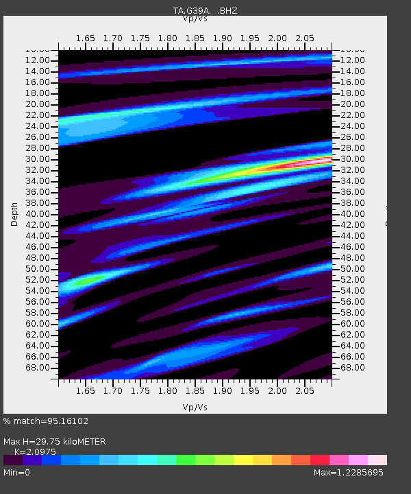
G39A Holcombe, WI, USA - Earthquake Result Viewer

Earthquake location: Fox Islands, Aleutian Islands
Earthquake latitude/longitude: 52.2/-171.7
Earthquake time(UTC): 2011/09/02 (245) 10:55:53 GMT
Earthquake Depth: 32 km
Earthquake Magnitude: 6.5 MB, 6.9 MS, 6.8 MW, 6.8 MW
Earthquake Catalog/Contributor: WHDF/NEIC
Network: TA USArray Transportable Network (new EarthScope stations)
Station: G39A Holcombe, WI, USA
Lat/Lon: 45.29 N/91.17 W
Elevation: 350 m
Distance: 51.0 deg
Az: 63.659 deg
Baz: 308.572 deg
Ray Param: 0.06763771
Estimated Moho Depth: 29.75 km
Estimated Crust Vp/Vs: 2.10
Assumed Crust Vp: 6.571 km/s
Estimated Crust Vs: 3.133 km/s
Estimated Crust Poisson's Ratio: 0.35
Radial Match: 95.16102 %
Radial Bump: 309
Transverse Match: 85.624695 %
Transverse Bump: 400
SOD ConfigId: 414626
Insert Time: 2012-01-18 07:48:36.112 +0000
GWidth: 2.5
Max Bumps: 400
Tol: 0.001

Signal To Noise

ChannelStoNSTALTA
TA:G39A: :BHZ:20110902T11:04:21.625004Z33.706173.0209044E-68.962467E-8
TA:G39A: :BHN:20110902T11:04:21.625004Z17.6196331.5242737E-68.650996E-8
TA:G39A: :BHE:20110902T11:04:21.625004Z18.147611.319617E-67.271575E-8
Arrivals
Ps5.2 SECOND
PpPs13 SECOND
PsPs/PpSs19 SECOND