You are here: Home > Network List > TA - USArray Transportable Network (new EarthScope stations) Stations List
> Station J01E Myrtle Point, OR, USA > Earthquake Result Viewer
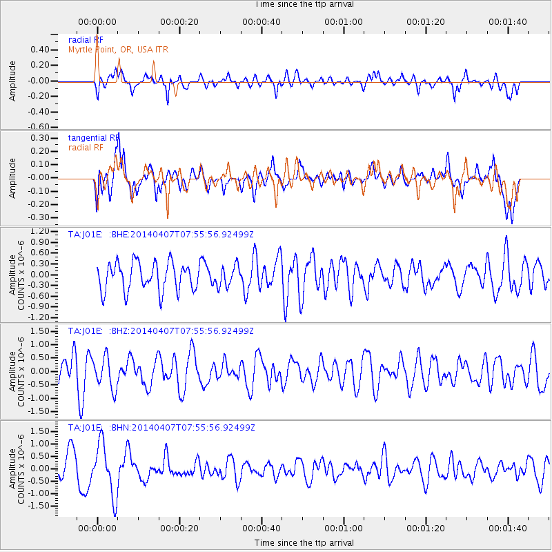
J01E Myrtle Point, OR, USA - Earthquake Result Viewer
*The percent match for this event was below the threshold and hence no stack was calculated.
| Earthquake location: |
Near Islands, Aleutian Islands |
| Earthquake latitude/longitude: |
53.0/171.0 |
| Earthquake time(UTC): |
2014/04/07 (097) 07:48:29 GMT |
| Earthquake Depth: |
26 km |
| Earthquake Magnitude: |
5.2 MW |
| Earthquake Catalog/Contributor: |
ISC/ISC |
|
| Network: |
TA USArray Transportable Network (new EarthScope stations) |
| Station: |
J01E Myrtle Point, OR, USA |
| Lat/Lon: |
43.16 N/123.93 W |
| Elevation: |
128 m |
|
| Distance: |
43.2 deg |
| Az: |
75.918 deg |
| Baz: |
306.694 deg |
| Ray Param: |
$rayparam |
*The percent match for this event was below the threshold and hence was not used in the summary stack. |
|
| Radial Match: |
56.114258 % |
| Radial Bump: |
400 |
| Transverse Match: |
53.722076 % |
| Transverse Bump: |
400 |
| SOD ConfigId: |
3390531 |
| Insert Time: |
2019-04-11 04:52:32.782 +0000 |
| GWidth: |
2.5 |
| Max Bumps: |
400 |
| Tol: |
0.001 |
|
Signal To Noise
| Channel | StoN | STA | LTA |
| TA:J01E: :BHZ:20140407T07:55:56.92499Z | 0.9604989 | 6.0973565E-7 | 6.348114E-7 |
| TA:J01E: :BHN:20140407T07:55:56.92499Z | 2.0103056 | 1.0912227E-6 | 5.4281435E-7 |
| TA:J01E: :BHE:20140407T07:55:56.92499Z | 0.7327304 | 2.8735292E-7 | 3.9216732E-7 |
| Arrivals |
| Ps | |
| PpPs | |
| PsPs/PpSs | |


