You are here: Home > Network List > TA - USArray Transportable Network (new EarthScope stations) Stations List
> Station F38A Pierce - Schroeder Farm, Trego, WI, USA > Earthquake Result Viewer
F38A Pierce - Schroeder Farm, Trego, WI, USA - Earthquake Result Viewer
| Earthquake location: |
Fox Islands, Aleutian Islands |
| Earthquake latitude/longitude: |
52.2/-171.7 |
| Earthquake time(UTC): |
2011/09/02 (245) 10:55:53 GMT |
| Earthquake Depth: |
32 km |
| Earthquake Magnitude: |
6.5 MB, 6.9 MS, 6.8 MW, 6.8 MW |
| Earthquake Catalog/Contributor: |
WHDF/NEIC |
|
| Network: |
TA USArray Transportable Network (new EarthScope stations) |
| Station: |
F38A Pierce - Schroeder Farm, Trego, WI, USA |
| Lat/Lon: |
45.96 N/91.88 W |
| Elevation: |
321 m |
|
| Distance: |
50.2 deg |
| Az: |
63.373 deg |
| Baz: |
307.886 deg |
| Ray Param: |
0.06816661 |
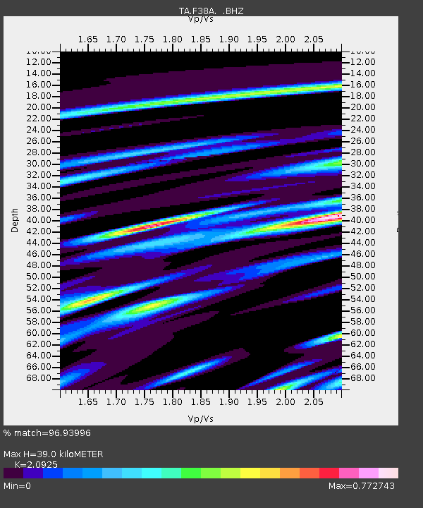
| Estimated Moho Depth: |
39.0 km |
| Estimated Crust Vp/Vs: |
2.09 |
| Assumed Crust Vp: |
6.571 km/s |
| Estimated Crust Vs: |
3.14 km/s |
| Estimated Crust Poisson's Ratio: |
0.35 |
|
| Radial Match: |
96.93996 % |
| Radial Bump: |
297 |
| Transverse Match: |
76.98124 % |
| Transverse Bump: |
400 |
| SOD ConfigId: |
414626 |
| Insert Time: |
2012-01-18 07:49:54.629 +0000 |
| GWidth: |
2.5 |
| Max Bumps: |
400 |
| Tol: |
0.001 |
|
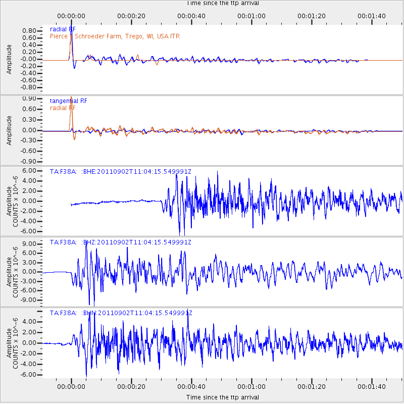
Signal To Noise
| Channel | StoN | STA | LTA |
| TA:F38A: :BHZ:20110902T11:04:15.549991Z | 24.86916 | 2.9417674E-6 | 1.1828977E-7 |
| TA:F38A: :BHN:20110902T11:04:15.549991Z | 7.4414015 | 1.3551016E-6 | 1.8210302E-7 |
| TA:F38A: :BHE:20110902T11:04:15.549991Z | 6.24011 | 1.4558719E-6 | 2.333087E-7 |
| Arrivals |
| Ps | 6.8 SECOND |
| PpPs | 17 SECOND |
| PsPs/PpSs | 24 SECOND |


