You are here: Home > Network List > UW - Pacific Northwest Regional Seismic Network Stations List
> Station MRBL Marblemount, WA, USA > Earthquake Result Viewer
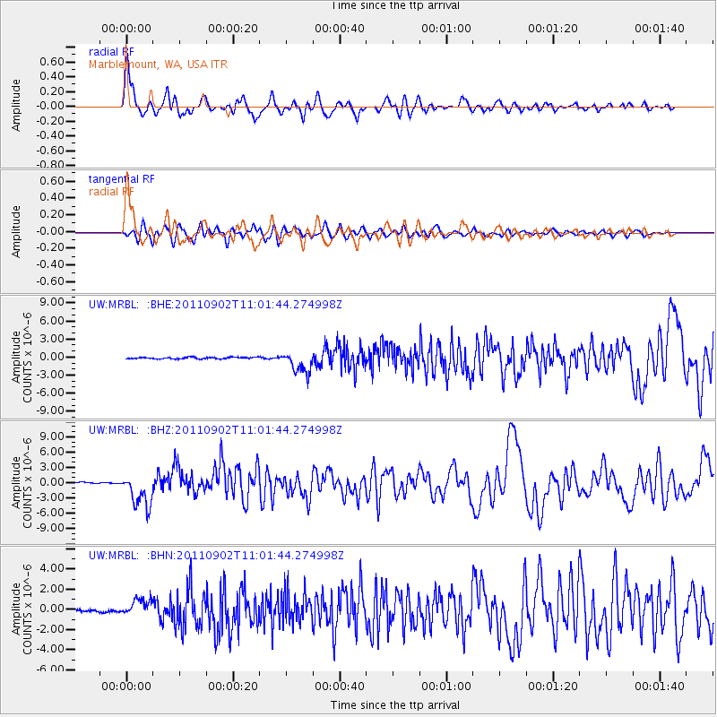
MRBL Marblemount, WA, USA - Earthquake Result Viewer
*The percent match for this event was below the threshold and hence no stack was calculated.
| Earthquake location: |
Fox Islands, Aleutian Islands |
| Earthquake latitude/longitude: |
52.2/-171.7 |
| Earthquake time(UTC): |
2011/09/02 (245) 10:55:53 GMT |
| Earthquake Depth: |
32 km |
| Earthquake Magnitude: |
6.5 MB, 6.9 MS, 6.8 MW, 6.8 MW |
| Earthquake Catalog/Contributor: |
WHDF/NEIC |
|
| Network: |
UW Pacific Northwest Regional Seismic Network |
| Station: |
MRBL Marblemount, WA, USA |
| Lat/Lon: |
48.52 N/121.48 W |
| Elevation: |
75 m |
|
| Distance: |
31.7 deg |
| Az: |
76.265 deg |
| Baz: |
295.866 deg |
| Ray Param: |
$rayparam |
*The percent match for this event was below the threshold and hence was not used in the summary stack. |
|
| Radial Match: |
76.94482 % |
| Radial Bump: |
400 |
| Transverse Match: |
65.46754 % |
| Transverse Bump: |
400 |
| SOD ConfigId: |
414626 |
| Insert Time: |
2012-01-18 07:52:52.988 +0000 |
| GWidth: |
2.5 |
| Max Bumps: |
400 |
| Tol: |
0.001 |
|
Signal To Noise
| Channel | StoN | STA | LTA |
| UW:MRBL: :BHZ:20110902T11:01:44.274998Z | 26.987844 | 3.3106314E-6 | 1.2267121E-7 |
| UW:MRBL: :BHN:20110902T11:01:44.274998Z | 8.411177 | 8.214018E-7 | 9.765599E-8 |
| UW:MRBL: :BHE:20110902T11:01:44.274998Z | 13.962058 | 1.8213606E-6 | 1.3045072E-7 |
| Arrivals |
| Ps | |
| PpPs | |
| PsPs/PpSs | |


