You are here: Home > Network List > CI - Caltech Regional Seismic Network Stations List
> Station FUR Furnace Creek, CA, USA > Earthquake Result Viewer
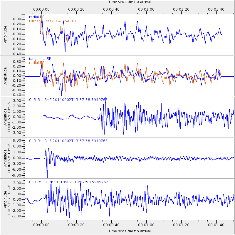
FUR Furnace Creek, CA, USA - Earthquake Result Viewer
*The percent match for this event was below the threshold and hence no stack was calculated.
| Earthquake location: |
Santiago Del Estero Prov., Arg. |
| Earthquake latitude/longitude: |
-28.4/-63.0 |
| Earthquake time(UTC): |
2011/09/02 (245) 13:47:09 GMT |
| Earthquake Depth: |
579 km |
| Earthquake Magnitude: |
6.4 MB, 6.7 MW, 6.7 MW |
| Earthquake Catalog/Contributor: |
WHDF/NEIC |
|
| Network: |
CI Caltech Regional Seismic Network |
| Station: |
FUR Furnace Creek, CA, USA |
| Lat/Lon: |
36.47 N/116.86 W |
| Elevation: |
-37.0 m |
|
| Distance: |
82.0 deg |
| Az: |
318.916 deg |
| Baz: |
134.092 deg |
| Ray Param: |
$rayparam |
*The percent match for this event was below the threshold and hence was not used in the summary stack. |
|
| Radial Match: |
81.47161 % |
| Radial Bump: |
400 |
| Transverse Match: |
75.04006 % |
| Transverse Bump: |
400 |
| SOD ConfigId: |
414626 |
| Insert Time: |
2012-01-18 08:31:22.215 +0000 |
| GWidth: |
2.5 |
| Max Bumps: |
400 |
| Tol: |
0.001 |
|
Signal To Noise
| Channel | StoN | STA | LTA |
| CI:FUR: :BHZ:20110902T13:57:58.594976Z | 23.15142 | 3.278209E-6 | 1.4159862E-7 |
| CI:FUR: :BHN:20110902T13:57:58.594976Z | 3.0760634 | 8.5920476E-7 | 2.7931958E-7 |
| CI:FUR: :BHE:20110902T13:57:58.594976Z | 3.4064877 | 7.63718E-7 | 2.2419513E-7 |
| Arrivals |
| Ps | |
| PpPs | |
| PsPs/PpSs | |


