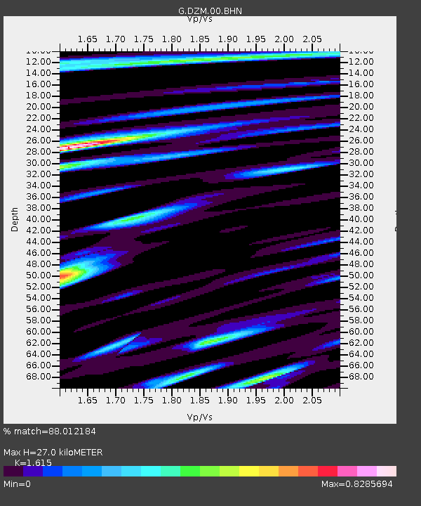
DZM Dzumac, New Caledonia - Earthquake Result Viewer
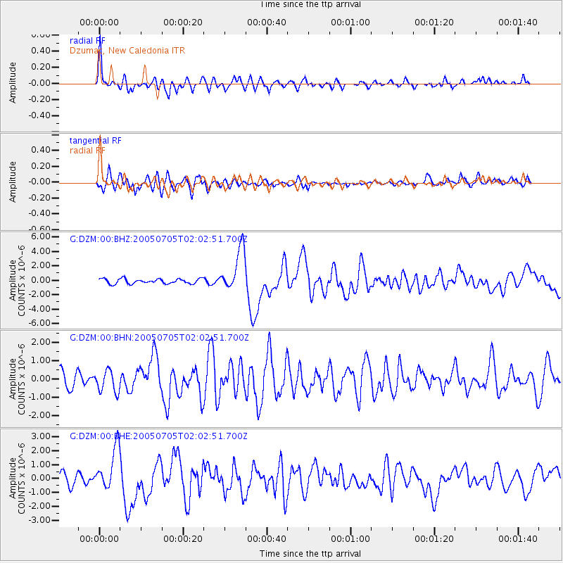
Earthquake location: Northern Sumatra, Indonesia
Earthquake latitude/longitude: 1.8/97.1
Earthquake time(UTC): 2005/07/05 (186) 01:52:02 GMT
Earthquake Depth: 21 km
Earthquake Magnitude: 6.2 MB, 6.8 MS, 6.7 MW, 6.6 MW
Earthquake Catalog/Contributor: WHDF/NEIC
Network: G GEOSCOPE
Station: DZM Dzumac, New Caledonia
Lat/Lon: 22.07 S/166.44 E
Elevation: 878 m
Distance: 71.6 deg
Az: 113.848 deg
Baz: 279.758 deg
Ray Param: 0.054171614
Estimated Moho Depth: 27.0 km
Estimated Crust Vp/Vs: 1.62
Assumed Crust Vp: 5.14 km/s
Estimated Crust Vs: 3.183 km/s
Estimated Crust Poisson's Ratio: 0.19
Radial Match: 88.012184 %
Radial Bump: 400
Transverse Match: 72.50635 %
Transverse Bump: 400
SOD ConfigId: 2564
Insert Time: 2010-02-26 22:17:08.233 +0000
GWidth: 2.5
Max Bumps: 400
Tol: 0.001

Signal To Noise

ChannelStoNSTALTA
G:DZM:00:BHN:20050705T02:02:51.700Z1.3622865.9264084E-74.3503408E-7
G:DZM:00:BHE:20050705T02:02:51.700Z3.69212561.5400357E-64.1711357E-7
G:DZM:00:BHZ:20050705T02:02:51.700Z9.1475063.0796332E-63.366637E-7
Arrivals
Ps3.3 SECOND
PpPs13 SECOND
PsPs/PpSs17 SECOND