You are here: Home > Network List > G - GEOSCOPE Stations List
> Station DZM Dzumac, New Caledonia > Earthquake Result Viewer
DZM Dzumac, New Caledonia - Earthquake Result Viewer
| Earthquake location: |
Macquarie Island Region |
| Earthquake latitude/longitude: |
-55.7/158.5 |
| Earthquake time(UTC): |
2008/04/12 (103) 00:30:12 GMT |
| Earthquake Depth: |
16 km |
| Earthquake Magnitude: |
6.8 MB, 7.1 MS, 7.1 MW, 7.1 MW |
| Earthquake Catalog/Contributor: |
WHDF/NEIC |
|
| Network: |
G GEOSCOPE |
| Station: |
DZM Dzumac, New Caledonia |
| Lat/Lon: |
22.07 S/166.44 E |
| Elevation: |
878 m |
|
| Distance: |
34.1 deg |
| Az: |
13.307 deg |
| Baz: |
188.083 deg |
| Ray Param: |
0.07790294 |
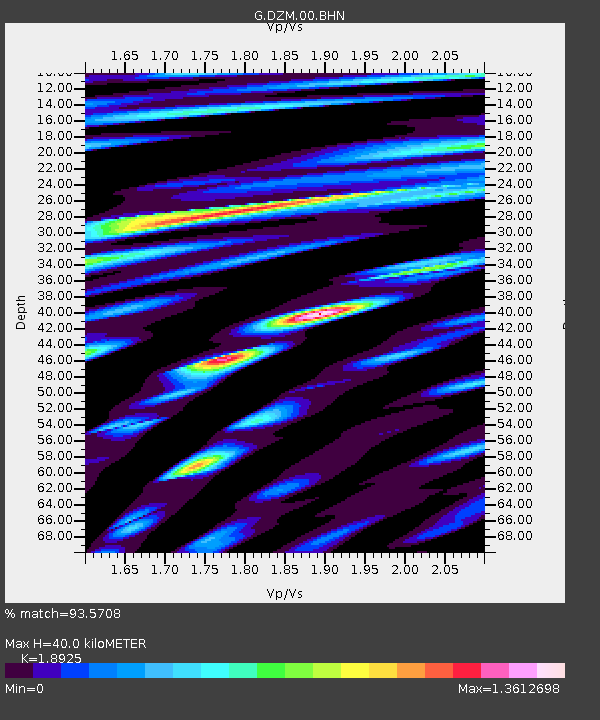
| Estimated Moho Depth: |
40.0 km |
| Estimated Crust Vp/Vs: |
1.89 |
| Assumed Crust Vp: |
5.14 km/s |
| Estimated Crust Vs: |
2.716 km/s |
| Estimated Crust Poisson's Ratio: |
0.31 |
|
| Radial Match: |
93.5708 % |
| Radial Bump: |
400 |
| Transverse Match: |
84.456436 % |
| Transverse Bump: |
400 |
| SOD ConfigId: |
2504 |
| Insert Time: |
2010-02-26 22:17:16.225 +0000 |
| GWidth: |
2.5 |
| Max Bumps: |
400 |
| Tol: |
0.001 |
|
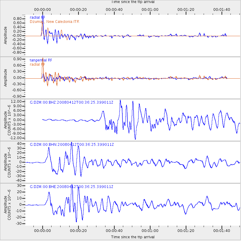
Signal To Noise
| Channel | StoN | STA | LTA |
| G:DZM:00:BHN:20080412T00:36:25.399011Z | 45.919216 | 1.3030313E-5 | 2.83766E-7 |
| G:DZM:00:BHE:20080412T00:36:25.399011Z | 18.381933 | 8.766788E-6 | 4.7692413E-7 |
| G:DZM:00:BHZ:20080412T00:36:25.399011Z | 7.9248004 | 2.7362369E-6 | 3.4527517E-7 |
| Arrivals |
| Ps | 7.3 SECOND |
| PpPs | 22 SECOND |
| PsPs/PpSs | 29 SECOND |


