You are here: Home > Network List > PE - Penn State Network Stations List
> Station PAGS PA Geological Survey > Earthquake Result Viewer
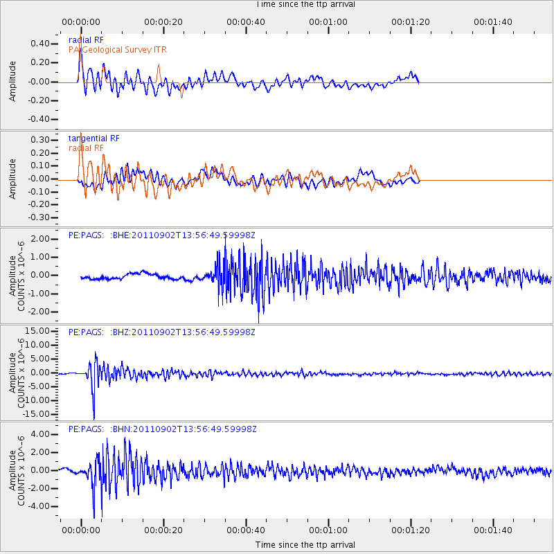
PAGS PA Geological Survey - Earthquake Result Viewer
*The percent match for this event was below the threshold and hence no stack was calculated.
| Earthquake location: |
Santiago Del Estero Prov., Arg. |
| Earthquake latitude/longitude: |
-28.4/-63.0 |
| Earthquake time(UTC): |
2011/09/02 (245) 13:47:09 GMT |
| Earthquake Depth: |
579 km |
| Earthquake Magnitude: |
6.4 MB, 6.7 MW, 6.7 MW |
| Earthquake Catalog/Contributor: |
WHDF/NEIC |
|
| Network: |
PE Penn State Network |
| Station: |
PAGS PA Geological Survey |
| Lat/Lon: |
40.23 N/76.72 W |
| Elevation: |
120 m |
|
| Distance: |
69.5 deg |
| Az: |
348.84 deg |
| Baz: |
167.131 deg |
| Ray Param: |
$rayparam |
*The percent match for this event was below the threshold and hence was not used in the summary stack. |
|
| Radial Match: |
75.841644 % |
| Radial Bump: |
400 |
| Transverse Match: |
80.05547 % |
| Transverse Bump: |
400 |
| SOD ConfigId: |
414626 |
| Insert Time: |
2012-01-18 08:44:25.914 +0000 |
| GWidth: |
2.5 |
| Max Bumps: |
400 |
| Tol: |
0.001 |
|
Signal To Noise
| Channel | StoN | STA | LTA |
| PE:PAGS: :BHZ:20110902T13:56:49.59998Z | 25.260393 | 4.528417E-6 | 1.7926946E-7 |
| PE:PAGS: :BHN:20110902T13:56:49.59998Z | 6.084368 | 1.3658323E-6 | 2.2448219E-7 |
| PE:PAGS: :BHE:20110902T13:56:49.59998Z | 3.7904303 | 5.2502463E-7 | 1.385132E-7 |
| Arrivals |
| Ps | |
| PpPs | |
| PsPs/PpSs | |


