You are here: Home > Network List > TA - USArray Transportable Network (new EarthScope stations) Stations List
> Station KMSC Kings Mountain, Blacksburg, SC, USA > Earthquake Result Viewer
KMSC Kings Mountain, Blacksburg, SC, USA - Earthquake Result Viewer

| Earthquake location: |
Santiago Del Estero Prov., Arg. |
| Earthquake latitude/longitude: |
-28.4/-63.0 |
| Earthquake time(UTC): |
2011/09/02 (245) 13:47:09 GMT |
| Earthquake Depth: |
579 km |
| Earthquake Magnitude: |
6.4 MB, 6.7 MW, 6.7 MW |
| Earthquake Catalog/Contributor: |
WHDF/NEIC |
|
| Network: |
TA USArray Transportable Network (new EarthScope stations) |
| Station: |
KMSC Kings Mountain, Blacksburg, SC, USA |
| Lat/Lon: |
35.14 N/81.33 W |
| Elevation: |
240 m |
|
| Distance: |
65.5 deg |
| Az: |
343.572 deg |
| Baz: |
162.301 deg |
| Ray Param: |
0.056089774 |
| Estimated Moho Depth: |
26.5 km |
| Estimated Crust Vp/Vs: |
2.09 |
| Assumed Crust Vp: |
6.419 km/s |
| Estimated Crust Vs: |
3.071 km/s |
| Estimated Crust Poisson's Ratio: |
0.35 |
|
| Radial Match: |
91.687645 % |
| Radial Bump: |
400 |
| Transverse Match: |
80.21357 % |
| Transverse Bump: |
400 |
| SOD ConfigId: |
414626 |
| Insert Time: |
2012-01-18 08:47:11.107 +0000 |
| GWidth: |
2.5 |
| Max Bumps: |
400 |
| Tol: |
0.001 |
|
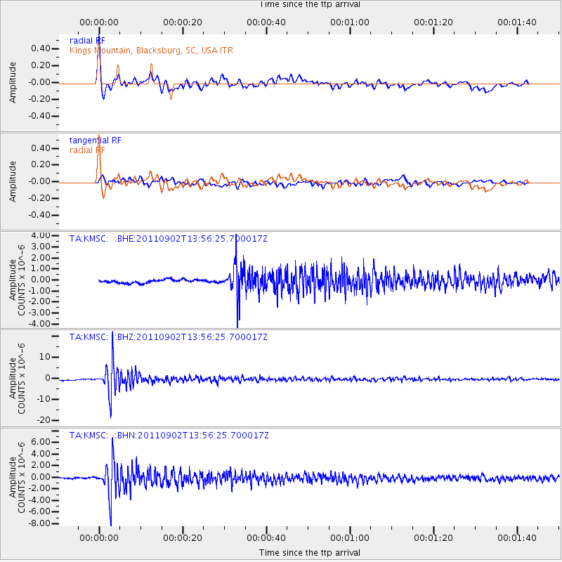
Signal To Noise
| Channel | StoN | STA | LTA |
| TA:KMSC: :BHZ:20110902T13:56:25.700017Z | 19.762669 | 7.04543E-6 | 3.5650191E-7 |
| TA:KMSC: :BHN:20110902T13:56:25.700017Z | 23.65728 | 2.8953805E-6 | 1.2238857E-7 |
| TA:KMSC: :BHE:20110902T13:56:25.700017Z | 9.330725 | 1.4122145E-6 | 1.51351E-7 |
| Arrivals |
| Ps | 4.6 SECOND |
| PpPs | 12 SECOND |
| PsPs/PpSs | 17 SECOND |


