You are here: Home > Network List > TA - USArray Transportable Network (new EarthScope stations) Stations List
> Station Z33A Whitaker Ranch, Olney, TX, USA > Earthquake Result Viewer
Z33A Whitaker Ranch, Olney, TX, USA - Earthquake Result Viewer
| Earthquake location: |
Santiago Del Estero Prov., Arg. |
| Earthquake latitude/longitude: |
-28.4/-63.0 |
| Earthquake time(UTC): |
2011/09/02 (245) 13:47:09 GMT |
| Earthquake Depth: |
579 km |
| Earthquake Magnitude: |
6.4 MB, 6.7 MW, 6.7 MW |
| Earthquake Catalog/Contributor: |
WHDF/NEIC |
|
| Network: |
TA USArray Transportable Network (new EarthScope stations) |
| Station: |
Z33A Whitaker Ranch, Olney, TX, USA |
| Lat/Lon: |
33.29 N/98.76 W |
| Elevation: |
362 m |
|
| Distance: |
70.1 deg |
| Az: |
328.647 deg |
| Baz: |
146.821 deg |
| Ray Param: |
0.05321991 |
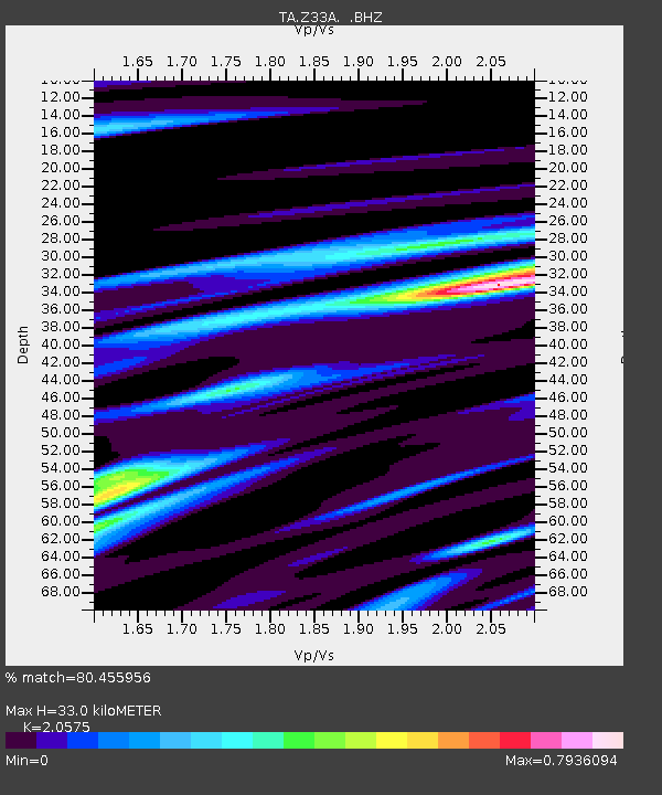
| Estimated Moho Depth: |
33.0 km |
| Estimated Crust Vp/Vs: |
2.06 |
| Assumed Crust Vp: |
6.426 km/s |
| Estimated Crust Vs: |
3.123 km/s |
| Estimated Crust Poisson's Ratio: |
0.35 |
|
| Radial Match: |
80.455956 % |
| Radial Bump: |
400 |
| Transverse Match: |
76.087616 % |
| Transverse Bump: |
400 |
| SOD ConfigId: |
414626 |
| Insert Time: |
2012-01-18 08:49:31.605 +0000 |
| GWidth: |
2.5 |
| Max Bumps: |
400 |
| Tol: |
0.001 |
|

Signal To Noise
| Channel | StoN | STA | LTA |
| TA:Z33A: :BHZ:20110902T13:56:53.375005Z | 62.499084 | 9.445585E-6 | 1.5113157E-7 |
| TA:Z33A: :BHN:20110902T13:56:53.375005Z | 10.217875 | 1.7412453E-6 | 1.7041171E-7 |
| TA:Z33A: :BHE:20110902T13:56:53.375005Z | 11.617399 | 1.7936823E-6 | 1.543962E-7 |
| Arrivals |
| Ps | 5.6 SECOND |
| PpPs | 15 SECOND |
| PsPs/PpSs | 21 SECOND |


