You are here: Home > Network List > TA - USArray Transportable Network (new EarthScope stations) Stations List
> Station 334A Lometa, TX, USA > Earthquake Result Viewer
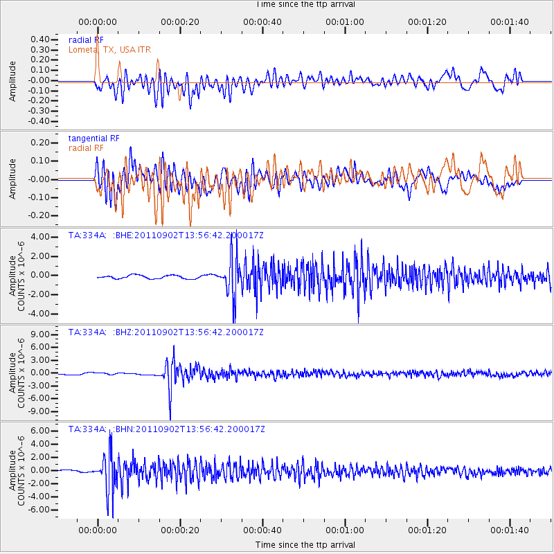
334A Lometa, TX, USA - Earthquake Result Viewer
*The percent match for this event was below the threshold and hence no stack was calculated.
| Earthquake location: |
Santiago Del Estero Prov., Arg. |
| Earthquake latitude/longitude: |
-28.4/-63.0 |
| Earthquake time(UTC): |
2011/09/02 (245) 13:47:09 GMT |
| Earthquake Depth: |
579 km |
| Earthquake Magnitude: |
6.4 MB, 6.7 MW, 6.7 MW |
| Earthquake Catalog/Contributor: |
WHDF/NEIC |
|
| Network: |
TA USArray Transportable Network (new EarthScope stations) |
| Station: |
334A Lometa, TX, USA |
| Lat/Lon: |
31.33 N/98.24 W |
| Elevation: |
389 m |
|
| Distance: |
68.2 deg |
| Az: |
327.906 deg |
| Baz: |
146.838 deg |
| Ray Param: |
$rayparam |
*The percent match for this event was below the threshold and hence was not used in the summary stack. |
|
| Radial Match: |
36.334343 % |
| Radial Bump: |
400 |
| Transverse Match: |
76.0014 % |
| Transverse Bump: |
400 |
| SOD ConfigId: |
414626 |
| Insert Time: |
2012-01-18 08:50:31.121 +0000 |
| GWidth: |
2.5 |
| Max Bumps: |
400 |
| Tol: |
0.001 |
|
Signal To Noise
| Channel | StoN | STA | LTA |
| TA:334A: :BHZ:20110902T13:56:42.200017Z | 1.7026682 | 2.1282722E-7 | 1.249963E-7 |
| TA:334A: :BHN:20110902T13:56:42.200017Z | 18.876045 | 2.8283175E-6 | 1.4983634E-7 |
| TA:334A: :BHE:20110902T13:56:42.200017Z | 11.431533 | 2.0266345E-6 | 1.7728459E-7 |
| Arrivals |
| Ps | |
| PpPs | |
| PsPs/PpSs | |


