You are here: Home > Network List > G - GEOSCOPE Stations List
> Station DZM Dzumac, New Caledonia > Earthquake Result Viewer
DZM Dzumac, New Caledonia - Earthquake Result Viewer
| Earthquake location: |
Southern Sumatra, Indonesia |
| Earthquake latitude/longitude: |
-2.9/101.4 |
| Earthquake time(UTC): |
2007/09/12 (255) 13:02:07 GMT |
| Earthquake Depth: |
35 km |
| Earthquake Magnitude: |
5.6 MB |
| Earthquake Catalog/Contributor: |
WHDF/NEIC |
|
| Network: |
G GEOSCOPE |
| Station: |
DZM Dzumac, New Caledonia |
| Lat/Lon: |
22.07 S/166.44 E |
| Elevation: |
878 m |
|
| Distance: |
65.8 deg |
| Az: |
112.782 deg |
| Baz: |
276.938 deg |
| Ray Param: |
0.057960372 |
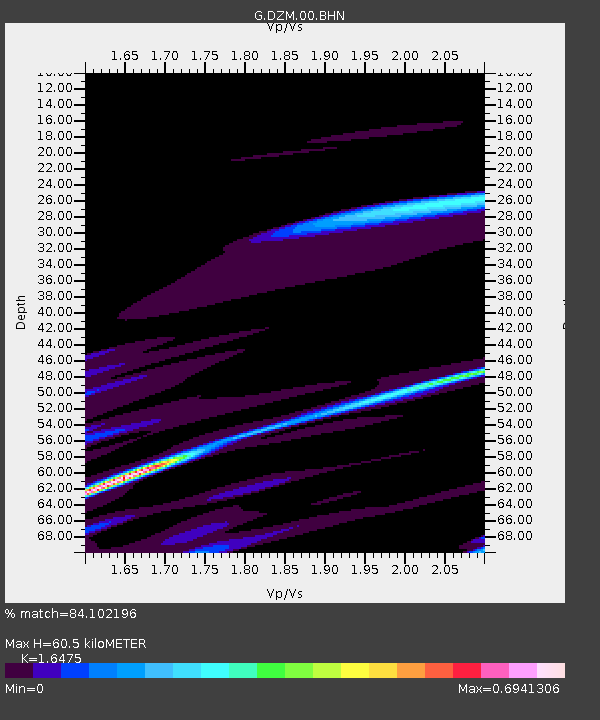
| Estimated Moho Depth: |
60.5 km |
| Estimated Crust Vp/Vs: |
1.65 |
| Assumed Crust Vp: |
5.14 km/s |
| Estimated Crust Vs: |
3.12 km/s |
| Estimated Crust Poisson's Ratio: |
0.21 |
|
| Radial Match: |
84.102196 % |
| Radial Bump: |
400 |
| Transverse Match: |
71.76736 % |
| Transverse Bump: |
400 |
| SOD ConfigId: |
2564 |
| Insert Time: |
2010-02-26 22:17:38.828 +0000 |
| GWidth: |
2.5 |
| Max Bumps: |
400 |
| Tol: |
0.001 |
|
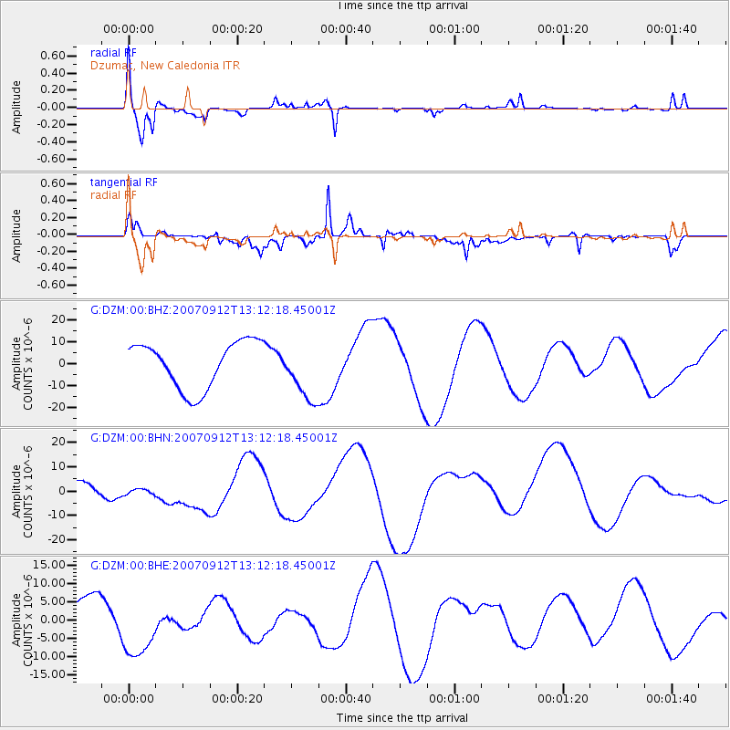
Signal To Noise
| Channel | StoN | STA | LTA |
| G:DZM:00:BHN:20070912T13:12:18.45001Z | 1.3612753 | 3.9188967E-6 | 2.8788422E-6 |
| G:DZM:00:BHE:20070912T13:12:18.45001Z | 2.3824403 | 9.764029E-6 | 4.098331E-6 |
| G:DZM:00:BHZ:20070912T13:12:18.45001Z | 1.2638277 | 1.3398663E-5 | 1.0601654E-5 |
| Arrivals |
| Ps | 7.8 SECOND |
| PpPs | 30 SECOND |
| PsPs/PpSs | 38 SECOND |


