You are here: Home > Network List > TA - USArray Transportable Network (new EarthScope stations) Stations List
> Station Q35A Mercer Eighty, Eskridge, KS, USA > Earthquake Result Viewer
Q35A Mercer Eighty, Eskridge, KS, USA - Earthquake Result Viewer
| Earthquake location: |
Santiago Del Estero Prov., Arg. |
| Earthquake latitude/longitude: |
-28.4/-63.0 |
| Earthquake time(UTC): |
2011/09/02 (245) 13:47:09 GMT |
| Earthquake Depth: |
579 km |
| Earthquake Magnitude: |
6.4 MB, 6.7 MW, 6.7 MW |
| Earthquake Catalog/Contributor: |
WHDF/NEIC |
|
| Network: |
TA USArray Transportable Network (new EarthScope stations) |
| Station: |
Q35A Mercer Eighty, Eskridge, KS, USA |
| Lat/Lon: |
38.86 N/96.04 W |
| Elevation: |
402 m |
|
| Distance: |
73.7 deg |
| Az: |
333.692 deg |
| Baz: |
149.993 deg |
| Ray Param: |
0.050939444 |
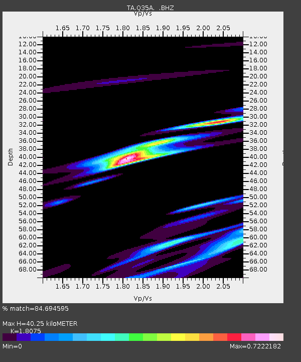
| Estimated Moho Depth: |
40.25 km |
| Estimated Crust Vp/Vs: |
1.81 |
| Assumed Crust Vp: |
6.483 km/s |
| Estimated Crust Vs: |
3.587 km/s |
| Estimated Crust Poisson's Ratio: |
0.28 |
|
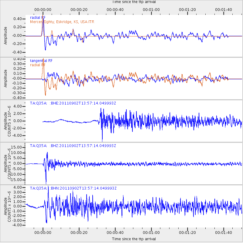
| Radial Match: |
84.694595 % |
| Radial Bump: |
400 |
| Transverse Match: |
82.19384 % |
| Transverse Bump: |
400 |
| SOD ConfigId: |
414626 |
| Insert Time: |
2012-01-18 08:57:52.272 +0000 |
| GWidth: |
2.5 |
| Max Bumps: |
400 |
| Tol: |
0.001 |
|
Signal To Noise
| Channel | StoN | STA | LTA |
| TA:Q35A: :BHZ:20110902T13:57:14.049993Z | 21.352852 | 5.1918278E-6 | 2.4314446E-7 |
| TA:Q35A: :BHN:20110902T13:57:14.049993Z | 8.072483 | 1.5225927E-6 | 1.8861516E-7 |
| TA:Q35A: :BHE:20110902T13:57:14.049993Z | 6.621508 | 1.556366E-6 | 2.3504705E-7 |
| Arrivals |
| Ps | 5.2 SECOND |
| PpPs | 17 SECOND |
| PsPs/PpSs | 22 SECOND |


