You are here: Home > Network List > TA - USArray Transportable Network (new EarthScope stations) Stations List
> Station 136A Ennis, TX, USA > Earthquake Result Viewer
136A Ennis, TX, USA - Earthquake Result Viewer
| Earthquake location: |
Santiago Del Estero Prov., Arg. |
| Earthquake latitude/longitude: |
-28.4/-63.0 |
| Earthquake time(UTC): |
2011/09/02 (245) 13:47:09 GMT |
| Earthquake Depth: |
579 km |
| Earthquake Magnitude: |
6.4 MB, 6.7 MW, 6.7 MW |
| Earthquake Catalog/Contributor: |
WHDF/NEIC |
|
| Network: |
TA USArray Transportable Network (new EarthScope stations) |
| Station: |
136A Ennis, TX, USA |
| Lat/Lon: |
32.47 N/96.53 W |
| Elevation: |
113 m |
|
| Distance: |
68.4 deg |
| Az: |
329.882 deg |
| Baz: |
148.467 deg |
| Ray Param: |
0.054286167 |
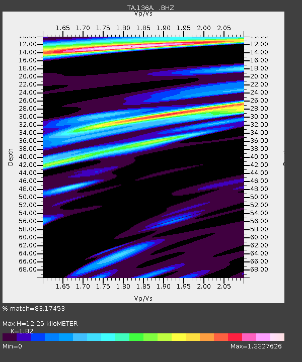
| Estimated Moho Depth: |
12.25 km |
| Estimated Crust Vp/Vs: |
1.82 |
| Assumed Crust Vp: |
6.38 km/s |
| Estimated Crust Vs: |
3.506 km/s |
| Estimated Crust Poisson's Ratio: |
0.28 |
|
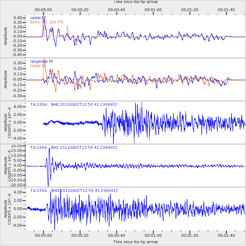
| Radial Match: |
83.17453 % |
| Radial Bump: |
400 |
| Transverse Match: |
82.06494 % |
| Transverse Bump: |
400 |
| SOD ConfigId: |
414626 |
| Insert Time: |
2012-01-18 08:59:42.855 +0000 |
| GWidth: |
2.5 |
| Max Bumps: |
400 |
| Tol: |
0.001 |
|
Signal To Noise
| Channel | StoN | STA | LTA |
| TA:136A: :BHZ:20110902T13:56:43.299993Z | 39.92506 | 8.137814E-6 | 2.0382723E-7 |
| TA:136A: :BHN:20110902T13:56:43.299993Z | 6.7466397 | 1.251636E-6 | 1.8551991E-7 |
| TA:136A: :BHE:20110902T13:56:43.299993Z | 4.491855 | 1.207445E-6 | 2.6880767E-7 |
| Arrivals |
| Ps | 1.6 SECOND |
| PpPs | 5.2 SECOND |
| PsPs/PpSs | 6.9 SECOND |


