You are here: Home > Network List > IU - Global Seismograph Network (GSN - IRIS/USGS) Stations List
> Station RSSD Black Hills, South Dakota, USA > Earthquake Result Viewer
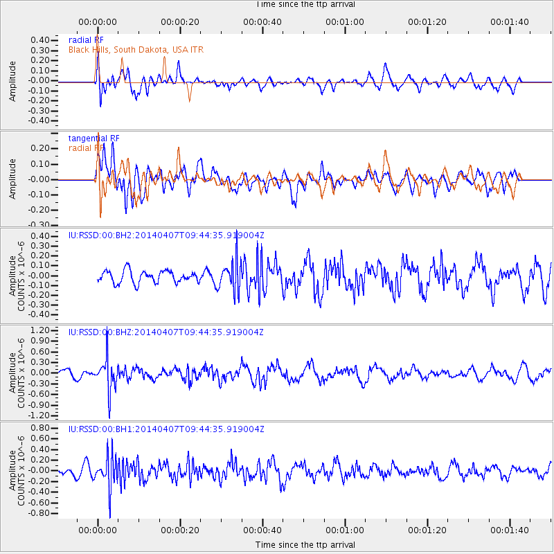
RSSD Black Hills, South Dakota, USA - Earthquake Result Viewer
*The percent match for this event was below the threshold and hence no stack was calculated.
| Earthquake location: |
Kuril Islands |
| Earthquake latitude/longitude: |
50.4/156.3 |
| Earthquake time(UTC): |
2014/04/07 (097) 09:34:49 GMT |
| Earthquake Depth: |
85 km |
| Earthquake Magnitude: |
5.2 MW |
| Earthquake Catalog/Contributor: |
ISC/ISC |
|
| Network: |
IU Global Seismograph Network (GSN - IRIS/USGS) |
| Station: |
RSSD Black Hills, South Dakota, USA |
| Lat/Lon: |
44.12 N/104.04 W |
| Elevation: |
2090 m |
|
| Distance: |
62.9 deg |
| Az: |
52.938 deg |
| Baz: |
314.869 deg |
| Ray Param: |
$rayparam |
*The percent match for this event was below the threshold and hence was not used in the summary stack. |
|
| Radial Match: |
53.431133 % |
| Radial Bump: |
400 |
| Transverse Match: |
63.423363 % |
| Transverse Bump: |
400 |
| SOD ConfigId: |
3390531 |
| Insert Time: |
2019-04-11 04:59:51.162 +0000 |
| GWidth: |
2.5 |
| Max Bumps: |
400 |
| Tol: |
0.001 |
|
Signal To Noise
| Channel | StoN | STA | LTA |
| IU:RSSD:00:BHZ:20140407T09:44:35.919004Z | 4.4783 | 4.599632E-7 | 1.0270933E-7 |
| IU:RSSD:00:BH1:20140407T09:44:35.919004Z | 2.4842741 | 2.9205555E-7 | 1.1756172E-7 |
| IU:RSSD:00:BH2:20140407T09:44:35.919004Z | 2.5106995 | 1.540601E-7 | 6.1361426E-8 |
| Arrivals |
| Ps | |
| PpPs | |
| PsPs/PpSs | |


