You are here: Home > Network List > TA - USArray Transportable Network (new EarthScope stations) Stations List
> Station C33A Trail, MN, USA > Earthquake Result Viewer
C33A Trail, MN, USA - Earthquake Result Viewer
| Earthquake location: |
Santiago Del Estero Prov., Arg. |
| Earthquake latitude/longitude: |
-28.4/-63.0 |
| Earthquake time(UTC): |
2011/09/02 (245) 13:47:09 GMT |
| Earthquake Depth: |
579 km |
| Earthquake Magnitude: |
6.4 MB, 6.7 MW, 6.7 MW |
| Earthquake Catalog/Contributor: |
WHDF/NEIC |
|
| Network: |
TA USArray Transportable Network (new EarthScope stations) |
| Station: |
C33A Trail, MN, USA |
| Lat/Lon: |
47.76 N/95.77 W |
| Elevation: |
388 m |
|
| Distance: |
81.3 deg |
| Az: |
338.336 deg |
| Baz: |
151.182 deg |
| Ray Param: |
0.045910493 |
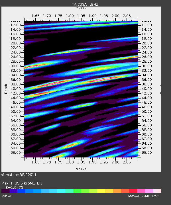
| Estimated Moho Depth: |
35.5 km |
| Estimated Crust Vp/Vs: |
1.95 |
| Assumed Crust Vp: |
6.419 km/s |
| Estimated Crust Vs: |
3.296 km/s |
| Estimated Crust Poisson's Ratio: |
0.32 |
|
| Radial Match: |
88.92011 % |
| Radial Bump: |
400 |
| Transverse Match: |
70.075325 % |
| Transverse Bump: |
400 |
| SOD ConfigId: |
414626 |
| Insert Time: |
2012-01-18 09:06:15.587 +0000 |
| GWidth: |
2.5 |
| Max Bumps: |
400 |
| Tol: |
0.001 |
|

Signal To Noise
| Channel | StoN | STA | LTA |
| TA:C33A: :BHZ:20110902T13:57:55.200017Z | 19.230341 | 4.895679E-6 | 2.5458098E-7 |
| TA:C33A: :BHN:20110902T13:57:55.200017Z | 25.407295 | 6.235934E-6 | 2.454387E-7 |
| TA:C33A: :BHE:20110902T13:57:55.200017Z | 15.651566 | 4.120526E-6 | 2.6326606E-7 |
| Arrivals |
| Ps | 5.4 SECOND |
| PpPs | 16 SECOND |
| PsPs/PpSs | 21 SECOND |


