You are here: Home > Network List > TA - USArray Transportable Network (new EarthScope stations) Stations List
> Station G31A Conde, SD, USA > Earthquake Result Viewer
G31A Conde, SD, USA - Earthquake Result Viewer
| Earthquake location: |
Santiago Del Estero Prov., Arg. |
| Earthquake latitude/longitude: |
-28.4/-63.0 |
| Earthquake time(UTC): |
2011/09/02 (245) 13:47:09 GMT |
| Earthquake Depth: |
579 km |
| Earthquake Magnitude: |
6.4 MB, 6.7 MW, 6.7 MW |
| Earthquake Catalog/Contributor: |
WHDF/NEIC |
|
| Network: |
TA USArray Transportable Network (new EarthScope stations) |
| Station: |
G31A Conde, SD, USA |
| Lat/Lon: |
45.23 N/98.21 W |
| Elevation: |
393 m |
|
| Distance: |
80.0 deg |
| Az: |
335.577 deg |
| Baz: |
148.972 deg |
| Ray Param: |
0.046821665 |
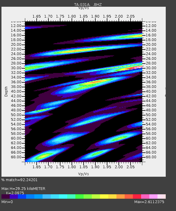
| Estimated Moho Depth: |
29.25 km |
| Estimated Crust Vp/Vs: |
2.10 |
| Assumed Crust Vp: |
6.53 km/s |
| Estimated Crust Vs: |
3.113 km/s |
| Estimated Crust Poisson's Ratio: |
0.35 |
|
| Radial Match: |
92.24201 % |
| Radial Bump: |
400 |
| Transverse Match: |
83.91899 % |
| Transverse Bump: |
400 |
| SOD ConfigId: |
414626 |
| Insert Time: |
2012-01-18 09:07:14.518 +0000 |
| GWidth: |
2.5 |
| Max Bumps: |
400 |
| Tol: |
0.001 |
|

Signal To Noise
| Channel | StoN | STA | LTA |
| TA:G31A: :BHZ:20110902T13:57:48.200017Z | 22.73919 | 6.8283416E-6 | 3.002896E-7 |
| TA:G31A: :BHN:20110902T13:57:48.200017Z | 10.67468 | 4.23156E-6 | 3.9641097E-7 |
| TA:G31A: :BHE:20110902T13:57:48.200017Z | 9.248616 | 3.3131744E-6 | 3.5823462E-7 |
| Arrivals |
| Ps | 5.0 SECOND |
| PpPs | 14 SECOND |
| PsPs/PpSs | 19 SECOND |


