You are here: Home > Network List > TA - USArray Transportable Network (new EarthScope stations) Stations List
> Station F34A Alexandria, MN, USA > Earthquake Result Viewer
F34A Alexandria, MN, USA - Earthquake Result Viewer

| Earthquake location: |
Santiago Del Estero Prov., Arg. |
| Earthquake latitude/longitude: |
-28.4/-63.0 |
| Earthquake time(UTC): |
2011/09/02 (245) 13:47:09 GMT |
| Earthquake Depth: |
579 km |
| Earthquake Magnitude: |
6.4 MB, 6.7 MW, 6.7 MW |
| Earthquake Catalog/Contributor: |
WHDF/NEIC |
|
| Network: |
TA USArray Transportable Network (new EarthScope stations) |
| Station: |
F34A Alexandria, MN, USA |
| Lat/Lon: |
45.80 N/95.26 W |
| Elevation: |
419 m |
|
| Distance: |
79.4 deg |
| Az: |
337.694 deg |
| Baz: |
151.449 deg |
| Ray Param: |
0.04717705 |
| Estimated Moho Depth: |
30.5 km |
| Estimated Crust Vp/Vs: |
2.09 |
| Assumed Crust Vp: |
6.571 km/s |
| Estimated Crust Vs: |
3.151 km/s |
| Estimated Crust Poisson's Ratio: |
0.35 |
|
| Radial Match: |
82.72123 % |
| Radial Bump: |
400 |
| Transverse Match: |
73.80047 % |
| Transverse Bump: |
400 |
| SOD ConfigId: |
414626 |
| Insert Time: |
2012-01-18 09:07:31.128 +0000 |
| GWidth: |
2.5 |
| Max Bumps: |
400 |
| Tol: |
0.001 |
|
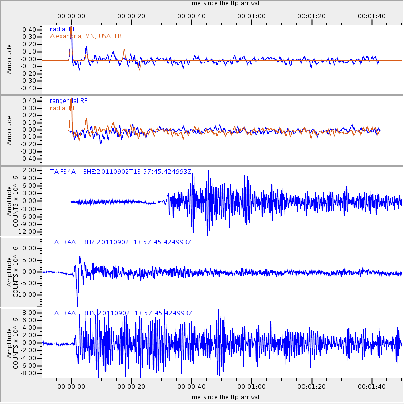
Signal To Noise
| Channel | StoN | STA | LTA |
| TA:F34A: :BHZ:20110902T13:57:45.424993Z | 20.239456 | 4.4885646E-6 | 2.2177299E-7 |
| TA:F34A: :BHN:20110902T13:57:45.424993Z | 9.039671 | 2.6885216E-6 | 2.9741364E-7 |
| TA:F34A: :BHE:20110902T13:57:45.424993Z | 6.225484 | 1.8898772E-6 | 3.0357114E-7 |
| Arrivals |
| Ps | 5.2 SECOND |
| PpPs | 14 SECOND |
| PsPs/PpSs | 19 SECOND |


