You are here: Home > Network List > TA - USArray Transportable Network (new EarthScope stations) Stations List
> Station C37A Embarrass, MN, USA > Earthquake Result Viewer
C37A Embarrass, MN, USA - Earthquake Result Viewer
| Earthquake location: |
Santiago Del Estero Prov., Arg. |
| Earthquake latitude/longitude: |
-28.4/-63.0 |
| Earthquake time(UTC): |
2011/09/02 (245) 13:47:09 GMT |
| Earthquake Depth: |
579 km |
| Earthquake Magnitude: |
6.4 MB, 6.7 MW, 6.7 MW |
| Earthquake Catalog/Contributor: |
WHDF/NEIC |
|
| Network: |
TA USArray Transportable Network (new EarthScope stations) |
| Station: |
C37A Embarrass, MN, USA |
| Lat/Lon: |
47.73 N/92.19 W |
| Elevation: |
447 m |
|
| Distance: |
80.2 deg |
| Az: |
340.501 deg |
| Baz: |
154.177 deg |
| Ray Param: |
0.04667663 |
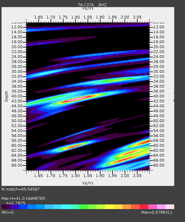
| Estimated Moho Depth: |
41.0 km |
| Estimated Crust Vp/Vs: |
1.80 |
| Assumed Crust Vp: |
6.571 km/s |
| Estimated Crust Vs: |
3.655 km/s |
| Estimated Crust Poisson's Ratio: |
0.28 |
|
| Radial Match: |
85.54567 % |
| Radial Bump: |
400 |
| Transverse Match: |
81.59655 % |
| Transverse Bump: |
400 |
| SOD ConfigId: |
414626 |
| Insert Time: |
2012-01-18 09:08:31.640 +0000 |
| GWidth: |
2.5 |
| Max Bumps: |
400 |
| Tol: |
0.001 |
|
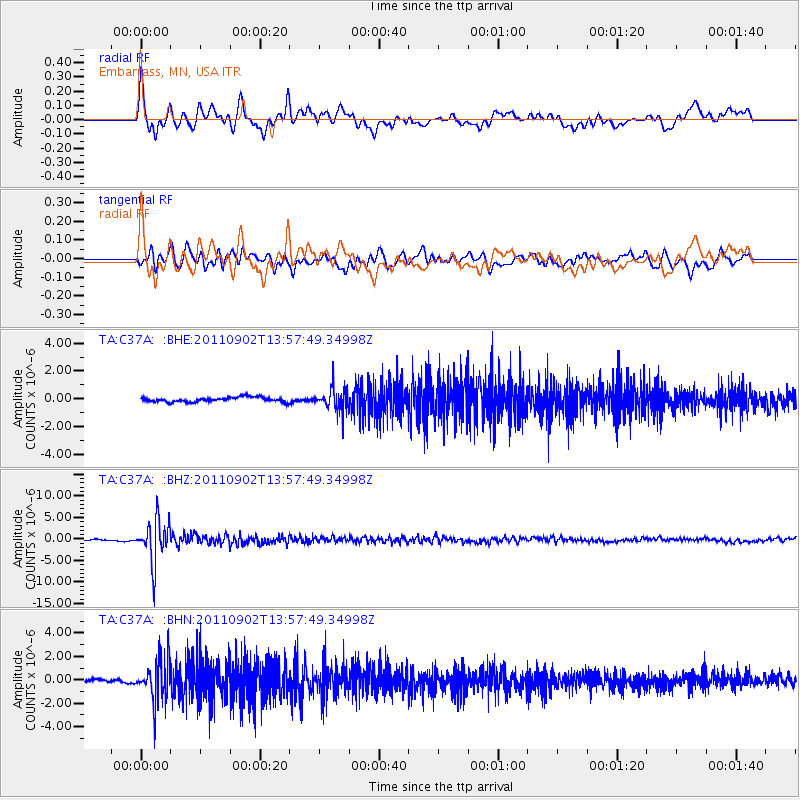
Signal To Noise
| Channel | StoN | STA | LTA |
| TA:C37A: :BHZ:20110902T13:57:49.34998Z | 29.872513 | 4.873084E-6 | 1.6312937E-7 |
| TA:C37A: :BHN:20110902T13:57:49.34998Z | 14.431449 | 1.7602536E-6 | 1.2197344E-7 |
| TA:C37A: :BHE:20110902T13:57:49.34998Z | 4.9550614 | 8.363037E-7 | 1.6877767E-7 |
| Arrivals |
| Ps | 5.1 SECOND |
| PpPs | 17 SECOND |
| PsPs/PpSs | 22 SECOND |


