You are here: Home > Network List > TA - USArray Transportable Network (new EarthScope stations) Stations List
> Station A33A Warroad, MN, USA > Earthquake Result Viewer
A33A Warroad, MN, USA - Earthquake Result Viewer

| Earthquake location: |
Santiago Del Estero Prov., Arg. |
| Earthquake latitude/longitude: |
-28.4/-63.0 |
| Earthquake time(UTC): |
2011/09/02 (245) 13:47:09 GMT |
| Earthquake Depth: |
579 km |
| Earthquake Magnitude: |
6.4 MB, 6.7 MW, 6.7 MW |
| Earthquake Catalog/Contributor: |
WHDF/NEIC |
|
| Network: |
TA USArray Transportable Network (new EarthScope stations) |
| Station: |
A33A Warroad, MN, USA |
| Lat/Lon: |
48.94 N/95.39 W |
| Elevation: |
329 m |
|
| Distance: |
82.2 deg |
| Az: |
339.133 deg |
| Baz: |
151.581 deg |
| Ray Param: |
0.045294777 |
| Estimated Moho Depth: |
51.75 km |
| Estimated Crust Vp/Vs: |
1.61 |
| Assumed Crust Vp: |
6.419 km/s |
| Estimated Crust Vs: |
3.981 km/s |
| Estimated Crust Poisson's Ratio: |
0.19 |
|
| Radial Match: |
86.28918 % |
| Radial Bump: |
400 |
| Transverse Match: |
75.47911 % |
| Transverse Bump: |
400 |
| SOD ConfigId: |
414626 |
| Insert Time: |
2012-01-18 09:08:56.456 +0000 |
| GWidth: |
2.5 |
| Max Bumps: |
400 |
| Tol: |
0.001 |
|
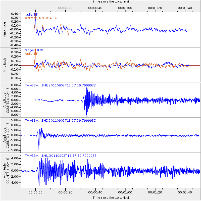
Signal To Noise
| Channel | StoN | STA | LTA |
| TA:A33A: :BHZ:20110902T13:57:59.799993Z | 17.11892 | 4.6968553E-6 | 2.7436636E-7 |
| TA:A33A: :BHN:20110902T13:57:59.799993Z | 15.423275 | 1.8170282E-6 | 1.17810785E-7 |
| TA:A33A: :BHE:20110902T13:57:59.799993Z | 9.158578 | 2.6757534E-6 | 2.9215818E-7 |
| Arrivals |
| Ps | 5.1 SECOND |
| PpPs | 20 SECOND |
| PsPs/PpSs | 26 SECOND |


