You are here: Home > Network List > TA - USArray Transportable Network (new EarthScope stations) Stations List
> Station I37A Lemond, Waseca, MN, USA > Earthquake Result Viewer
I37A Lemond, Waseca, MN, USA - Earthquake Result Viewer
| Earthquake location: |
Santiago Del Estero Prov., Arg. |
| Earthquake latitude/longitude: |
-28.4/-63.0 |
| Earthquake time(UTC): |
2011/09/02 (245) 13:47:09 GMT |
| Earthquake Depth: |
579 km |
| Earthquake Magnitude: |
6.4 MB, 6.7 MW, 6.7 MW |
| Earthquake Catalog/Contributor: |
WHDF/NEIC |
|
| Network: |
TA USArray Transportable Network (new EarthScope stations) |
| Station: |
I37A Lemond, Waseca, MN, USA |
| Lat/Lon: |
44.01 N/93.40 W |
| Elevation: |
371 m |
|
| Distance: |
77.2 deg |
| Az: |
338.036 deg |
| Baz: |
152.825 deg |
| Ray Param: |
0.048623897 |
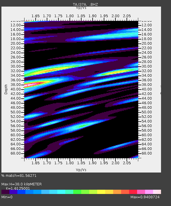
| Estimated Moho Depth: |
38.0 km |
| Estimated Crust Vp/Vs: |
1.61 |
| Assumed Crust Vp: |
6.571 km/s |
| Estimated Crust Vs: |
4.075 km/s |
| Estimated Crust Poisson's Ratio: |
0.19 |
|
| Radial Match: |
81.56271 % |
| Radial Bump: |
400 |
| Transverse Match: |
80.18901 % |
| Transverse Bump: |
400 |
| SOD ConfigId: |
414626 |
| Insert Time: |
2012-01-18 09:09:35.415 +0000 |
| GWidth: |
2.5 |
| Max Bumps: |
400 |
| Tol: |
0.001 |
|
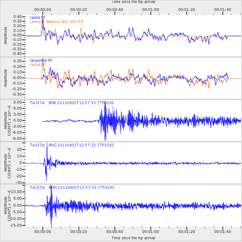
Signal To Noise
| Channel | StoN | STA | LTA |
| TA:I37A: :BHZ:20110902T13:57:33.775029Z | 27.190952 | 8.067973E-6 | 2.9671534E-7 |
| TA:I37A: :BHN:20110902T13:57:33.775029Z | 16.723957 | 4.2146153E-6 | 2.5201064E-7 |
| TA:I37A: :BHE:20110902T13:57:33.775029Z | 11.506265 | 2.9987698E-6 | 2.6062062E-7 |
| Arrivals |
| Ps | 3.7 SECOND |
| PpPs | 15 SECOND |
| PsPs/PpSs | 18 SECOND |


