You are here: Home > Network List > TA - USArray Transportable Network (new EarthScope stations) Stations List
> Station M37A Trindle Farm, Earlham, IA, USA > Earthquake Result Viewer
M37A Trindle Farm, Earlham, IA, USA - Earthquake Result Viewer
| Earthquake location: |
Santiago Del Estero Prov., Arg. |
| Earthquake latitude/longitude: |
-28.4/-63.0 |
| Earthquake time(UTC): |
2011/09/02 (245) 13:47:09 GMT |
| Earthquake Depth: |
579 km |
| Earthquake Magnitude: |
6.4 MB, 6.7 MW, 6.7 MW |
| Earthquake Catalog/Contributor: |
WHDF/NEIC |
|
| Network: |
TA USArray Transportable Network (new EarthScope stations) |
| Station: |
M37A Trindle Farm, Earlham, IA, USA |
| Lat/Lon: |
41.40 N/94.06 W |
| Elevation: |
325 m |
|
| Distance: |
75.2 deg |
| Az: |
336.349 deg |
| Baz: |
151.979 deg |
| Ray Param: |
0.04998287 |
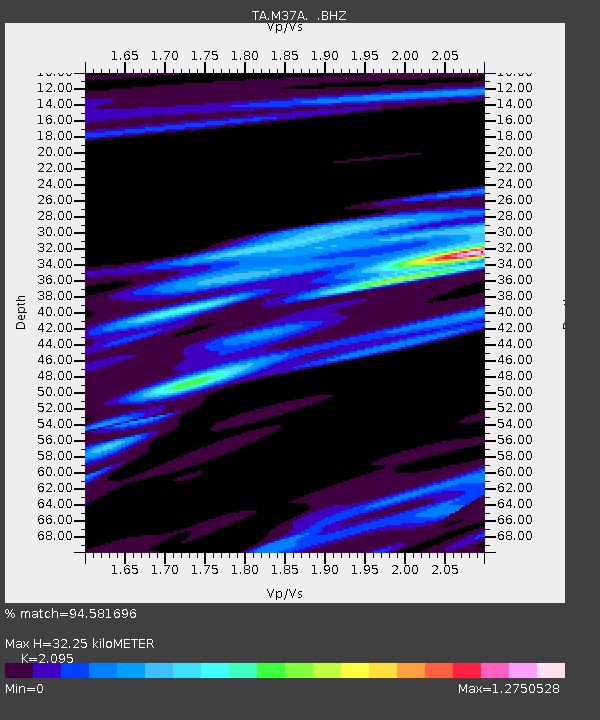
| Estimated Moho Depth: |
32.25 km |
| Estimated Crust Vp/Vs: |
2.10 |
| Assumed Crust Vp: |
6.498 km/s |
| Estimated Crust Vs: |
3.101 km/s |
| Estimated Crust Poisson's Ratio: |
0.35 |
|
| Radial Match: |
94.581696 % |
| Radial Bump: |
400 |
| Transverse Match: |
78.83518 % |
| Transverse Bump: |
400 |
| SOD ConfigId: |
414626 |
| Insert Time: |
2012-01-18 09:11:03.752 +0000 |
| GWidth: |
2.5 |
| Max Bumps: |
400 |
| Tol: |
0.001 |
|

Signal To Noise
| Channel | StoN | STA | LTA |
| TA:M37A: :BHZ:20110902T13:57:22.34998Z | 45.753696 | 1.7093113E-5 | 3.7358976E-7 |
| TA:M37A: :BHN:20110902T13:57:22.34998Z | 79.17694 | 1.699932E-5 | 2.1470039E-7 |
| TA:M37A: :BHE:20110902T13:57:22.34998Z | 48.40796 | 1.4997082E-5 | 3.0980613E-7 |
| Arrivals |
| Ps | 5.6 SECOND |
| PpPs | 15 SECOND |
| PsPs/PpSs | 21 SECOND |


