You are here: Home > Network List > TA - USArray Transportable Network (new EarthScope stations) Stations List
> Station O38A Galt, MO, USA > Earthquake Result Viewer
O38A Galt, MO, USA - Earthquake Result Viewer

| Earthquake location: |
Santiago Del Estero Prov., Arg. |
| Earthquake latitude/longitude: |
-28.4/-63.0 |
| Earthquake time(UTC): |
2011/09/02 (245) 13:47:09 GMT |
| Earthquake Depth: |
579 km |
| Earthquake Magnitude: |
6.4 MB, 6.7 MW, 6.7 MW |
| Earthquake Catalog/Contributor: |
WHDF/NEIC |
|
| Network: |
TA USArray Transportable Network (new EarthScope stations) |
| Station: |
O38A Galt, MO, USA |
| Lat/Lon: |
40.12 N/93.47 W |
| Elevation: |
266 m |
|
| Distance: |
73.8 deg |
| Az: |
336.136 deg |
| Baz: |
152.302 deg |
| Ray Param: |
0.050845187 |
| Estimated Moho Depth: |
31.75 km |
| Estimated Crust Vp/Vs: |
2.08 |
| Assumed Crust Vp: |
6.498 km/s |
| Estimated Crust Vs: |
3.124 km/s |
| Estimated Crust Poisson's Ratio: |
0.35 |
|
| Radial Match: |
87.62535 % |
| Radial Bump: |
400 |
| Transverse Match: |
79.53819 % |
| Transverse Bump: |
400 |
| SOD ConfigId: |
414626 |
| Insert Time: |
2012-01-18 09:12:27.166 +0000 |
| GWidth: |
2.5 |
| Max Bumps: |
400 |
| Tol: |
0.001 |
|
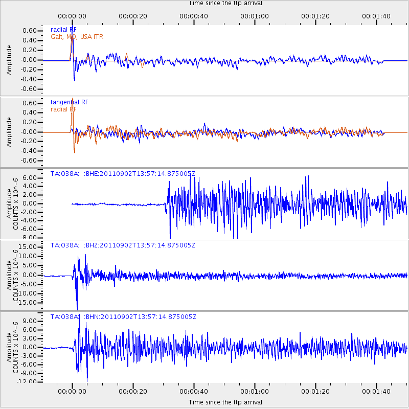
Signal To Noise
| Channel | StoN | STA | LTA |
| TA:O38A: :BHZ:20110902T13:57:14.875005Z | 43.887653 | 5.4469847E-6 | 1.24112E-7 |
| TA:O38A: :BHN:20110902T13:57:14.875005Z | 32.739338 | 4.096676E-6 | 1.2513009E-7 |
| TA:O38A: :BHE:20110902T13:57:14.875005Z | 18.934158 | 2.201569E-6 | 1.1627499E-7 |
| Arrivals |
| Ps | 5.4 SECOND |
| PpPs | 15 SECOND |
| PsPs/PpSs | 20 SECOND |


