DZM Dzumac, New Caledonia - Earthquake Result Viewer
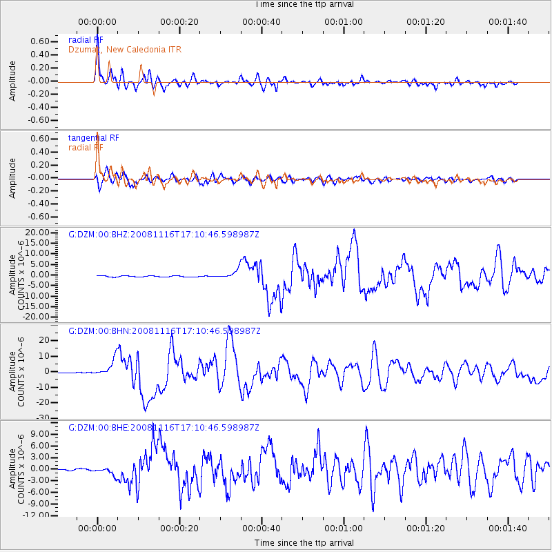
Earthquake location: Minahassa Peninsula, Sulawesi
Earthquake latitude/longitude: 1.3/122.1
Earthquake time(UTC): 2008/11/16 (321) 17:02:32 GMT
Earthquake Depth: 30 km
Earthquake Magnitude: 6.5 MB, 7.0 MS, 7.3 MW, 7.3 MW
Earthquake Catalog/Contributor: WHDF/NEIC
Network: G GEOSCOPE
Station: DZM Dzumac, New Caledonia
Lat/Lon: 22.07 S/166.44 E
Elevation: 878 m
Distance: 49.1 deg
Az: 120.902 deg
Baz: 292.361 deg
Ray Param: 0.06886975
Estimated Moho Depth: 25.75 km
Estimated Crust Vp/Vs: 1.66
Assumed Crust Vp: 5.14 km/s
Estimated Crust Vs: 3.087 km/s
Estimated Crust Poisson's Ratio: 0.22
Radial Match: 93.91044 %
Radial Bump: 400
Transverse Match: 92.81652 %
Transverse Bump: 400
SOD ConfigId: 2658
Insert Time: 2010-02-26 22:17:54.427 +0000
GWidth: 2.5
Max Bumps: 400
Tol: 0.001

Signal To Noise

ChannelStoNSTALTA
G:DZM:00:BHN:20081116T17:10:46.598987Z27.9670035.8447486E-62.0898732E-7
G:DZM:00:BHE:20081116T17:10:46.598987Z6.9166291.0739902E-61.5527654E-7
G:DZM:00:BHZ:20081116T17:10:46.598987Z7.3048262.0369584E-62.7885105E-7
Arrivals
Ps3.5 SECOND
PpPs13 SECOND
PsPs/PpSs16 SECOND