You are here: Home > Network List > TA - USArray Transportable Network (new EarthScope stations) Stations List
> Station Y40A Okolona, AR, USA > Earthquake Result Viewer
Y40A Okolona, AR, USA - Earthquake Result Viewer

| Earthquake location: |
Santiago Del Estero Prov., Arg. |
| Earthquake latitude/longitude: |
-28.4/-63.0 |
| Earthquake time(UTC): |
2011/09/02 (245) 13:47:09 GMT |
| Earthquake Depth: |
579 km |
| Earthquake Magnitude: |
6.4 MB, 6.7 MW, 6.7 MW |
| Earthquake Catalog/Contributor: |
WHDF/NEIC |
|
| Network: |
TA USArray Transportable Network (new EarthScope stations) |
| Station: |
Y40A Okolona, AR, USA |
| Lat/Lon: |
34.01 N/93.28 W |
| Elevation: |
117 m |
|
| Distance: |
68.4 deg |
| Az: |
333.244 deg |
| Baz: |
151.479 deg |
| Ray Param: |
0.0543087 |
| Estimated Moho Depth: |
38.0 km |
| Estimated Crust Vp/Vs: |
2.00 |
| Assumed Crust Vp: |
6.498 km/s |
| Estimated Crust Vs: |
3.257 km/s |
| Estimated Crust Poisson's Ratio: |
0.33 |
|
| Radial Match: |
88.17586 % |
| Radial Bump: |
400 |
| Transverse Match: |
84.00859 % |
| Transverse Bump: |
400 |
| SOD ConfigId: |
414626 |
| Insert Time: |
2012-01-18 09:14:08.987 +0000 |
| GWidth: |
2.5 |
| Max Bumps: |
400 |
| Tol: |
0.001 |
|
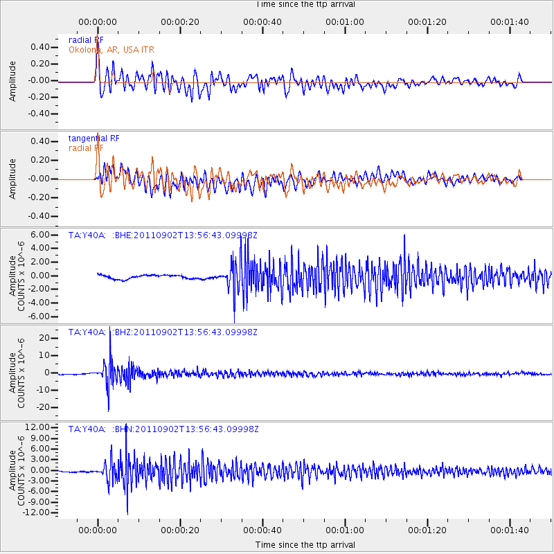
Signal To Noise
| Channel | StoN | STA | LTA |
| TA:Y40A: :BHZ:20110902T13:56:43.09998Z | 23.114159 | 7.098815E-6 | 3.0711976E-7 |
| TA:Y40A: :BHN:20110902T13:56:43.09998Z | 15.496693 | 2.5953207E-6 | 1.6747578E-7 |
| TA:Y40A: :BHE:20110902T13:56:43.09998Z | 7.6638303 | 2.1046135E-6 | 2.746164E-7 |
| Arrivals |
| Ps | 6.0 SECOND |
| PpPs | 17 SECOND |
| PsPs/PpSs | 23 SECOND |


