You are here: Home > Network List > TA - USArray Transportable Network (new EarthScope stations) Stations List
> Station U39A Green Forest, AR, USA > Earthquake Result Viewer
U39A Green Forest, AR, USA - Earthquake Result Viewer
| Earthquake location: |
Santiago Del Estero Prov., Arg. |
| Earthquake latitude/longitude: |
-28.4/-63.0 |
| Earthquake time(UTC): |
2011/09/02 (245) 13:47:09 GMT |
| Earthquake Depth: |
579 km |
| Earthquake Magnitude: |
6.4 MB, 6.7 MW, 6.7 MW |
| Earthquake Catalog/Contributor: |
WHDF/NEIC |
|
| Network: |
TA USArray Transportable Network (new EarthScope stations) |
| Station: |
U39A Green Forest, AR, USA |
| Lat/Lon: |
36.38 N/93.48 W |
| Elevation: |
433 m |
|
| Distance: |
70.5 deg |
| Az: |
334.29 deg |
| Baz: |
151.732 deg |
| Ray Param: |
0.05294849 |
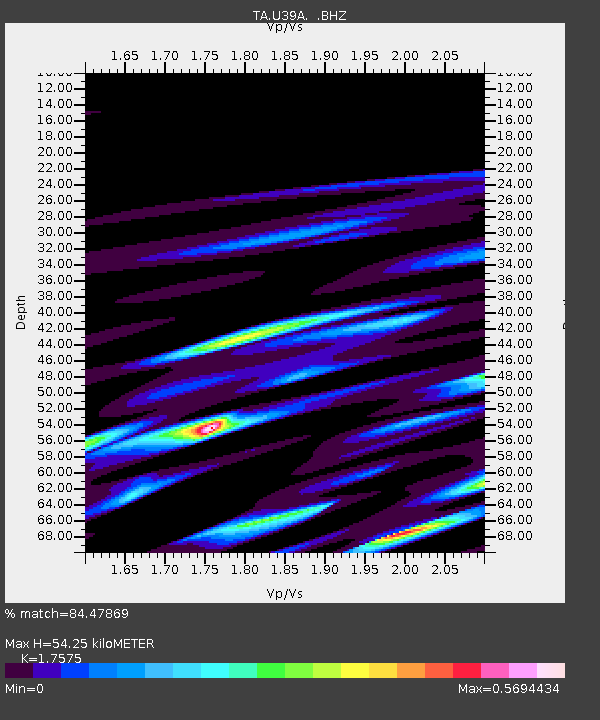
| Estimated Moho Depth: |
54.25 km |
| Estimated Crust Vp/Vs: |
1.76 |
| Assumed Crust Vp: |
6.53 km/s |
| Estimated Crust Vs: |
3.716 km/s |
| Estimated Crust Poisson's Ratio: |
0.26 |
|
| Radial Match: |
84.47869 % |
| Radial Bump: |
400 |
| Transverse Match: |
85.18347 % |
| Transverse Bump: |
400 |
| SOD ConfigId: |
414626 |
| Insert Time: |
2012-01-18 09:14:25.738 +0000 |
| GWidth: |
2.5 |
| Max Bumps: |
400 |
| Tol: |
0.001 |
|

Signal To Noise
| Channel | StoN | STA | LTA |
| TA:U39A: :BHZ:20110902T13:56:55.924993Z | 23.1032 | 5.8095616E-6 | 2.5146133E-7 |
| TA:U39A: :BHN:20110902T13:56:55.924993Z | 12.944796 | 2.0057103E-6 | 1.5494338E-7 |
| TA:U39A: :BHE:20110902T13:56:55.924993Z | 8.916512 | 1.4565594E-6 | 1.633553E-7 |
| Arrivals |
| Ps | 6.5 SECOND |
| PpPs | 22 SECOND |
| PsPs/PpSs | 29 SECOND |


